|
|||
|
|
|||
|
|
|
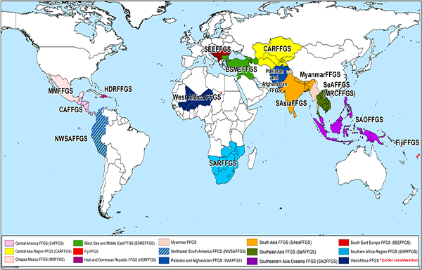
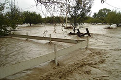
Flash Flood Guidance System (FFGS) with Global CoverageFlash floods are among the world’s deadliest natural disasters with more than 5,000 lives lost annually and result in significant social, economic and environmental impacts. Accounting for approximately 85% of the flooding cases, flash floods also have the highest mortality rate (defined as the number of deaths per number of people affected) among different classes of flooding (e.g., riverine, coastal). Flash floods have a different character than river floods, notably short time scales and occurring in small spatial scales, which make forecasting of flash floods quite a different challenge than traditional flood forecasting approaches. In forecasting of flash floods, we are concerned foremost with the forecast of occurrence, and herein have focused on two causative events: 1. heavy rainfall and 2. rainfall on saturated soils. Flash floods occur throughout the world, and the time thresholds vary across regions from minutes to several hours depending on land surface, geomorphological, and hydroclimatological characteristics of the region. However, for the majority of these areas there exists no formal process for flash flood warnings, there is a lack of general capacity to develop effective warnings for these quick response events. Click on the Regional project on the map to access the relevant document.
Flash Flood Guidance System with Global Coverage (Magnify picture)
Regional FFGS projectsWithin the scope of Global FFGS implementation, the following regional projects have been implemented or are under implementation:
A system such as the FFGS is an important tool necessary to provide operational forecasters and disaster management agencies with real-time informational guidance products pertaining to the threat of small-scale flash flooding. The FFGS is a robust system designed to provide the necessary products to support the development of warnings for flash floods from rainfall events through the use of remote sensed precipitation (e.g., radar and satellite-based rainfall estimates) and hydrological models. To assess the threat of a local flash flood, the FFGS is designed to allow product adjustments based on forecaster experience with local conditions, incorporation of other information (e.g., Numerical Weather Prediction output) and any last minute local observations (e.g., non-traditional rain gauge data) or local observer reports.
Training is a crucial part of the Flash Flood Guidance System to allow forecasters to be able to use its products effectively in daily operations. Therefore, extensive training programme was designed in five steps in pedagogical order. Learn more about the FFGS training content. The Project Brief provides overview of the Flash Flood Guidance System (FFGS) while the Black Sea and Middle East Flash Flood Guidance System (BSMEFFGS) User Guide provides detailed description of the FFGS products such as Satellite Precipitation (GHE), Merged Mean Aereal Precipitation (Merged MAP), Average Soil Moisture (ASM), Forecast Mean Aereal Precipitation (FMAP), Flash Flood Guidance (FFG), Flash Flood Threats (FFT), Snow Water Equivalent (SWE), Snow Coverage (SCA), snow MELT, FFGS user interface, flash flood warning verification, case studies, and references. To obtain more information please contact WMO at: and visit Hydrologic Research Center (HRC) web site: http://www.hrcwater.org.
|
|
|||||||||||
 ©2017 World Meteorological Organization, 7bis, avenue de la Paix, CP No. 2300, CH-1211 Geneva 2, Switzerland - Tel.: +41(0)22 730 81 11 - Fax: +41(0)22 730 81 81 |
|||||||||||||

 Recognizing that flash floods have a particularly disastrous impact on lives and properties of the affected populations, the Fifteenth WMO Congress had approved the implementation of a Flash Flood Guidance System (FFGS) project with global coverage that had been developed by the WMO Commission for Hydrology (CHy) jointly with the WMO Commission for Basic Systems (CBS) and in collaboration with the US National Weather Service, the US Hydrologic Research Center (HRC) and USAID/OFDA.
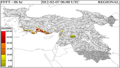 The primary purpose of the FFGS is to provide training forecasters with real-time informational guidance products for flash floods. If the system is used frequently, implementation experience has shown that the knowledge and experience of trained forecasters increases over time. They are better able to identify their individual strengths and weaknesses in relation to their abilities to forecast flash floods and to assess the forecast uncertainty. They are also able to identify areas where their local knowledge and the FFGS provide applicable and realistic results, as well as gaining a sense of the meteorological and hydrological conditions that are likely to lead to flash flooding for their country.
")
")