| Hydrology and Water Resources Programme (HWRP) |
 |
|
 |
Programmes > HWRP > floods > FFGS > Training Programme
Flash Flood Guidance System (FFGS) Training Programme
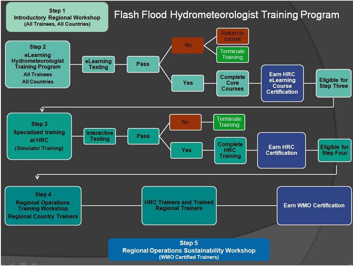
Training of hydrometeorologists is an integral part of implementation of the global Flash Flood Guidance System and is of critical importance in establishing sustainable local capabilities within the participating National Meteorological and Hydrological Services. The training programme is designed in a pedagogic way to ensure trainees receive the most benefits; and it consists of five steps (see below schematic).
Trainees who have successfully completed Step 2 receive the Hydrologic Research Center (HRC) eLearning Course Certification, with an additional HRC Certification being provided when Step 3 training has been successfully completed. When all steps have been successfully completed, the trainee will be awarded WMO certification as a FFGS trainer.
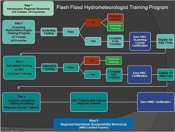
Steps of the Flash Flood Guidance System training programme (click on the picture to enlarge)
Step 1- Introductory Regional Workshop
- Flash Flood Guidance System overview,
- Introduction to FFG models and products,
- Local Data requirements.
Step 2- eLearning (Distance Learning)
- Elements of Meteorology;
-
Factors necessary to produce heavy rainfall,
- Elements necessary for deep moisture convection,
- Characteristics of flash flood producing storms,
- Examples of flash flood producing storms,
- Meteorological processes that contribute to flash floods.
- Elements of Hydrology;
- Water cycle,
- Surface hydrology,
- Sub-Surface hydrology,
- Flash Floods-unique properties.
- Geographical Information System (GIS);
- Description of GIS-introduction of concepts and application of QGIS,
- Applied use of GIS-as related to flash floods,
- Manipulation of the Flash Flood Guidance products data using QGIS,
-
Practical exercises.
- Remote Sensing;
- Satellite rainfall,
- Radar rainfall,
- Land Surface Remote Sensing.
- Flash Flood Guidance System Products;
- Description of Flash Flood Guidance System-introduction concepts and applications,
- Types of analysis available using the Flash Flood Guidance model,
- Practical exercises using the Flash Flood Guidance model.
Step 3-Specialized Training at Hydrologic Research Center (HRC)
Advanced operation and simulation training focuses on in-depth understanding of the system and its operational capabilities. Those trainees, who pass the step 2 Distance Learning module, are eligible to participate in Step 3 module.
- Flash floods as hydrometeorological phenomena - Design fundamentals of operational flash flood warnings systems,
- Use of remote sensing as part of FFG system – bias adjustment, errors, dynamic bias adjustment,
- Explanation of climatological bias adjustments for the FFG system,
- System development and theoretical background - Soil Moisture Modelling and FFG Models - Evapotranspiration Modelling,
- GIS Procedures – Basin Delineations - Threshold Runoff,
- Introduction to GIS Application, with hands-on examples,
- Instruction on the application of climatological bias adjustments,
- Discussion of Radar Hydrology,
- Model calibration and validation of soil and snow water components,
- Trainee Presentation - Flash flood issues/examples in the region,
- Forecaster/IT System Administrative Cooperation,
- Concept of Forecast Operations Review and warning protocol development,
- Hand out case studies.
Step 4 –Regional operational training
Training is provided at the Regional Centre. Trainees, who participate and successfully complete previous steps and step 4, will receive WMO certificate.
- Technical background and system description,
- Operational use of the flash flood guidance products through hand-out case studies,
- Participants review and evaluation of FFG system products for selected events.
Step 5- Regional operational sustainability workshop
Step 5 workshops are led by WMO certified trainers who will train forecasters from the participant countries. It will ensure continuous training of operational forecasters and enhance flash flood forecasting and early warning capabilities.
- Brief discussion of the technical background and system development,
- Operational use of FFG system products through case studies,
- Verification.
Flash Flood Guidance System (FFGS) Trainings Status