|
|||
|
|
|||
|
|
|
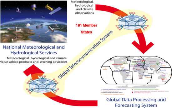
WMO Operational Network Last updated: 16 August 2018 WMO coordinates the work of the National Meteorological and Hydrological Services (NMHSs) of its 191 Members which operate thea number of global systems:
Figure 1: Internationally coordinated network of WMO involving Global Observing System, Global Telecommunication System and Global Data Processing and Forecasting System facilitating sharing of data, analysis and forecasts across 191 WMO Members through their National meteorological and Hydrological Services. Building on this network, WMO is working with its Members to strengthen and establish new Regional Climate Centres (RCCs) and Regional Drought Management Centres (RDMCs).
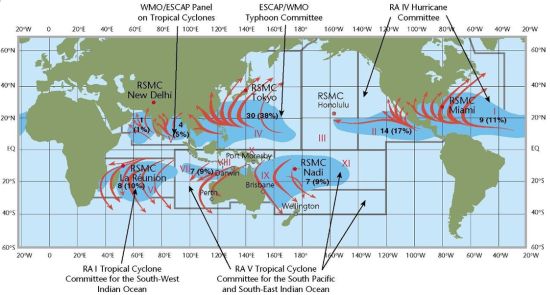
Examples of WMO programmes and activities relevant to DRR Tropical Cyclone Programme (TCP) The Tropical Cyclone Programme (TCP) is an example of cooperation using regional capacities to support national warning systems to promote DRR strategies. Through TCP, six Regional Specialized Meteorological Centres (RSNCs, specifically the Tropical Cyclone Warning Centres (TCWCs)) are dedicated to providing tropical cyclone analysis, forecasts and alerts in support of NMHSs' operational warnings. The Programme is supported by five regional committees, involving forecasters from the NMHSs, which ensure ongoing improvements in the tropical cyclone forecasting and warning systems. This has enabled availability of tropical cyclone warning capacities to all countries at risk.
Figure 2: WMO network of Tropical Cyclone Specialized Centres, a model for sustained cooperation. Emergency Response Activitie (ERA) Programme The Chernobyl nuclear accident (April 1986) led to strengthened international cooperation in the event of a nuclear emergency through the Joint Radiation Emergency Management Plan of the International Organizations. The plan is coordinated by the International Atomic Energy Agency in cooperation with international organizations including WMO, the World Health Organization, and the Food and Agriculture Organization. WMO maintains a system of eight Regional Specialized Meteorological Centres which provide highly specialized computer-based simulations of the atmosphere that predict the long-range movement of airborne radioactivity to support environmental emergency response, when needed. These centres, which provide complete global coverage 24 hours a day, every day, are located in Beijing (China), Obninsk (Russian Federation) Tokyo (Japan), Exeter (United Kingdom), Toulouse (France), Melbourne (Australia), Montreal (Canada) and Washington D.C. (USA). This response system was activated on 12 March 2011 in the aftermath of the earthquake in Japan. Volcanic ash is a direct safety threat to jet transport aircraft, primarily because the melting point of ash is around 1100°C, while the operating temperatures of jet engines are around 1400°C. The ash melts in the hot section of the engines and then fuses on the turbine blades, eventually leading to engine stall. The International Civil Aviation Organization is responsible for coordinating the efforts of its member states and seven international organizations, including WMO, which comprise the International Airways Volcano Watch (IAVW). Under the IAVW, international ground-based networks, global satellite systems and in-flight air reports detect and observe volcanic eruptions and ash cloud and pass the information quickly to appropriate air traffic services units and Meteorological Watch Offices, which provide the necessary warnings to aircraft before or during flight. The warnings are based on advisory information supplied by nine Volcanic Ash Advisory Centres (VAACs) designated upon advice from WMO. The designated VAACs are located in Anchorage (USA), Buenos Aires (Chile), Darwin (Australia), London (United Kingdom), Montreal (Canada), Tokyo (Japan), Toulouse (France), Washington D. C. (USA) and Wellington (New Zealand). Wildfires Following the worst smoke and haze episodes that affected South-East Asia in autumn 1997, which impacted many socio-economic sectors including civil aviation, maritime shipping, agricultural production, tourism and the health of populations, WMO joined with the Association of South-East Asian Nations (ASEAN) to set up the ASEAN Regional Specialized Meteorological Centre in Singapore. This Centre provides smoke/haze information and forecasts to NMHSs to assist in environmental emergency situations. It also displays weather and hot spots using satellite images on its website. Satellite imagery can provide information on the dryness of vegetation, location and size of major fires and smoke plumes, energy released by fires, and air pollutants in the smoke plumes. Integrated Flood Management Integrated Drought Management The intent is to support actors and partners in various sectors, disciplines, and institutions to provide better drought monitoring and prediction on a global and regional basis, and to use the information effectively in the development of short-term and long-term drought management plans and actions. The Programme will be demand-driven, tailored to specific regional and national needs and requirements. Regional cooperation is critical to making accessible the latest hazard analysis and forecasting information to those countries with fewer resources. WMO has promoted strong regional cooperation among Members in terms of meteorological, cliamte and hydrological services. WMO facilitates information sharing and capacity building through its 30 Regional Training Centres (RTCs). Strengthening of these facilities and enhanced cooperation enables NMHSs to provide better information in support of decision-making. The RTCs provide equipment, facilities, instruction and training to respond to the needs of each region. Through the activities of these centres, NMHSs have received extensive training, ranging from hazard monitoring to issuing of early warnings.
|
|||||||||||||
 ©2019 World Meteorological Organization, 7bis, avenue de la Paix, CP No. 2300, CH-1211 Geneva 2, Switzerland - Tel.: +41(0)22 730 81 11 - Fax: +41(0)22 730 81 81 |
||||||||||||||