| Disaster Risk Reduction (DRR) Programme |
 |
Programmes > DRR >
WMO Disaster Risk Reduction Activities - Introduction
Last updated: 20 November 2018
Disaster risk reduction (DRR) is at the core of the mission of the World Meteorological Organization (WMO), and the National Meteorological and Hydrological Services(NMHSs) of its 191 Members. WMO, through its scientific and technical programmes, its network of Global Meteorological Centresand Regional Specialized Meteorological and Climate Centres, and the NMHSs, provide scientific and technical services. This includes observing, detecting, monitoring, predicting and early warning of a wide range of weather–, climate- and water-related hazards. Through a coordinated approach, and working with its partners, WMO addresses the information needs and requirements of the disaster risk management community in an effective and timely fashion.
Every year, disasters related to meteorological, hydrological and climate hazards cause significant loss of life, and set back economic and social development by years, if not decades.
From 1970 to 2012, 8,835 weather, climate and water-related disasters were reported globally. Together they caused the loss of 1.94 million lives and economic damages of US$ 2.4 trillion. The worst ten reported disasters in terms of human lives lost represented only 0.1 per cent of the total number of events but accounted for 69 per cent of the total lives lost (1.34 million). The ten most costly disasters accounted for 19 per cent of overall economic losses (US$ 443.6 billion). Storms, droughts, floods and extreme temperatures all figure on both lists of the worst disasters. Storms and floods accounted for 79 per cent of the total number of disasters due to weather, water, and climate extremes and caused 55 per cent of lives lost and 86 per cent of economic losses. Droughts caused 35 per cent of lives lost, mainly due to the severe African droughts of 1975 and 1983–1984.
In 2005, government’s endorsed the “Hyogo Framework for Action 2005-2015: Building the Resilience of Nations and Communities to Disasters (HFA) to build the resilience of nations and communities to disasters. HFA calls for a paradigm shift: from emergency response to a more proactive, holistic and systematic approach with strong focus on risk reduction.
The paradigm shift from post disaster response to a proactive risk reduction approach requires meteorological, hydrological and climate services to support science-based risk management decisions, as well as investments in early warning systems (Figure 1). |
A lone house standing after hurricane Ike (2008).
Source: http://abcnews.go.com/WN/Weather/story?id=5852406&page=1 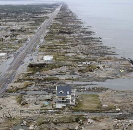
A lone house remains standing after Hurricane Ike (2008) devastated Gilchrist and Galveston, Texas, United States of America. The house was rebuilt taking advantage of lessons learned from Hurricane Rita, which struck the area in 2005. It was built on elevated ground and the pitch of the roof and the windows were designed to withstand winds of up to 209 km per hour, thus surviving Hurricane Ike and its winds of 177 km per hour.
Source: ABC News |
An increasing number of countries are taking steps at national to local levels to reduce risks associated with natural hazards. Among issues hampering these efforts is a lack of data concerning a country’s past climate to quantify hazard characteristics (e.g., frequency, severity and location) of local climatic extremes in the future.
DRR is therefore one of the high priorities for the development of the Global Framework for Climate Services (GFCS), to meet both the growing needs and opportunities to increase disaster resilience. With appropriate use of meteorological, hydrological and climate information as part of a comprehensive multi-sector, multi-hazard, and multi-level (local to global) approach, considerable achievements can be realized.
An essential starting point for reducing risks is a quantitative assessment which combines information about the hazards with exposures and vulnerabilities of the population or assets (e.g., agricultural production, infrastructure and homes, etc). The hazard side of the equation uses historical data and forward looking modelling and forecasting about environmental conditions such as tropical cyclones, rainfall, soil moisture and hill slope stability, mountain weather patterns and river basin hydrology. This must be augmented with socio-economic data that quantifies exposure and vulnerability (for instance casualties, construction damages, crop yield reduction and water shortages). Equipped with the quantitative risk information, countries can develop risk management strategies using early warning systems to reduce casualties; medium and long-term sectoral planning (such as land zoning, infrastructure development, water resource management, agricultural planning) to reduce economic losses and build livelihood resilience, and weather-indexed insurance and risk financing mechanisms to transfer the financial impacts of disasters. This must be underpinned by effective policies, legislation and legal frameworks, and institutional coordination mechanisms as well as information and knowledge sharing, education and training.
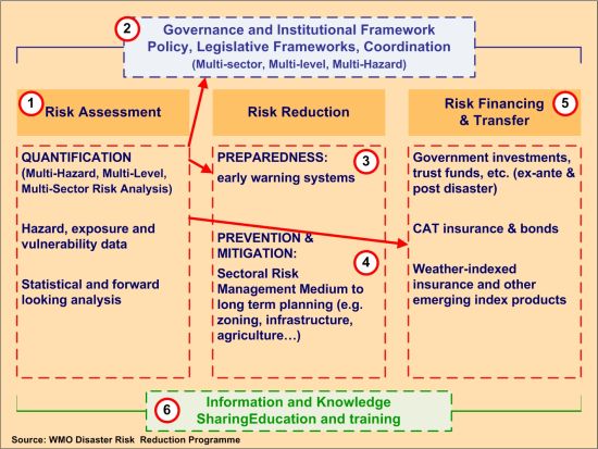
Figure 1: Elements of a comprehensive DRR Framework based on the Hyogo Framework for Action 2005-2015
The emergence of climate prediction provides opportunities to increase the lead times of early warnings (Figure 2). For instance, seasonal climate outlooks help governments predict – and manage – excessive or deficient rainfall. Historical data has traditionally been used for analysis of hazards patterns. But this is no longer sufficient, because hazard characteristics are changing as a result of climate change. For instance a 100-year flood or drought may become a 30-year flood or drought or, simply said, more severe events could happen more frequently in the future weather and climate services with forecasts from the next hour to seasonal through to decadal time scales are therefore needed to inform long-term investments and strategic planning, for instance, coastal zone management, development of new building codes and the retrofitting of infrastructure to withstand more frequent and severe hazards.
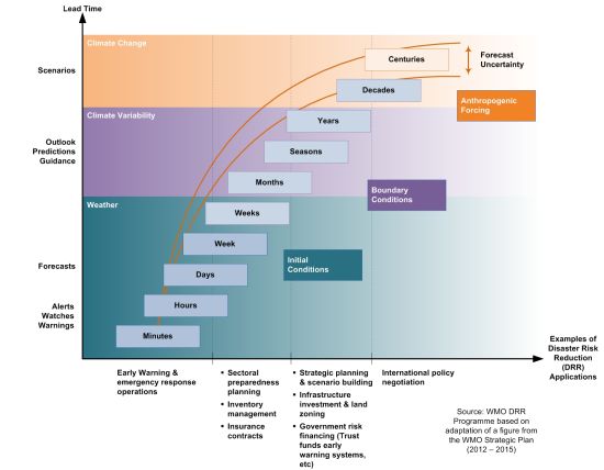
Figure 2: Seamless hydrometeorological and climate services for various risk management applications


