| Global Data Processing and Forecasting Systems (GDPFS) |
 |
Programmes > WWW > SWFDP
WMO Severe Weather Forecasting Demonstration Project (SWFDP)
The Severe Weather Forecasting Demonstration Project (SWFDP) since its inception in 2006 has been successfully strengthening capacity of National Meteorological and Hydrological Services (NMHSs) in developing countries including least developed countries (LDCs) and Small Island Developing States (SIDSs) to deliver improved forecasts and warnings of severe weather to save lives and livelihoods, and protect property and infrastructure.
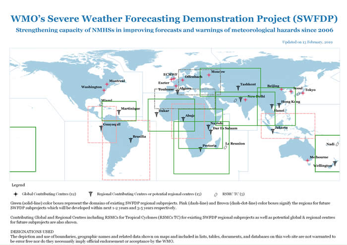
The project was started with involvement of just 5 countries in south-eastern Africa in 2006. Currently, it involves and benefits over 75 developing countries, LDCs and SIDS in eight sub-regions including Southern Africa, South Pacific, Eastern Africa, South-East Asia, Bay of Bengal (South Asia), Central Asia, West Africa and Eastern Caribbean, with contributions from various global and regional centres and support from donors/partners.
The project has proven to improve the lead-time and reliability for alerts and warnings about high-impact events such as heavy precipitation, strong winds and high waves. It has been strengthening engagement of NMHSs with users including media, disaster management and civil protection agencies and local communities for improved disaster risk reduction (DRR) and decision making process by users. The project is benefiting to various socio-economic sectors as well, including agriculture, fisheries, aviation, and marine transportation.
SWFDP is making contributions to the WMO Strategic Priorities for 2016-2019, especially in areas of DRR, GFCS (through climate change adaptation by building climate resilence) and Capacity Development. Through these contributions and owing to its potential operational support to Multi-Hazard Early Warning Systems (MHEWS) at regional and national levels, the SWFDP aims to support the UN 2030 Agenda for
Sustainable Development (Sustainable Development Goals) and the Sendai Framework for DRR 2015-2030.
Countries participating in the project are able to benefit from advances in the science of weather forecasting, especially the dramatic development in Numerical Weather Prediction (NWP) including Ensemble Prediction Systems (EPS) which give guidance to weather forecasters in advance of potential hazardous weather conditions for issuance of alerts and warnings.
SWFDP uses a “Cascading Forecasting Process” (global to regional, to national).
- Global NWP centres provide available NWP and EPS products, including in the form of probabilities for a specific time frame;
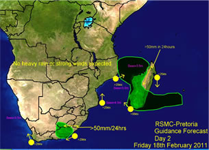
- Regional Specialized Meteorological Centres (RSMCs) interpret information received from global centres, prepare daily guidance products (1-5 day) for distribution to National Meteorological Centres (NMCs) and maintain the regional centre Web site;
- National Meteorological Centres (NMCs) issue alerts, advisories, severe weather warnings to public via the media and other dissemination channels; liaise with disaster management, and certain economic sectors, and contribute feedback and evaluation of the project.
The SWFDP is primarily built on the Global Data Processing and Forecasting System (GDPFS) programme, in collaboration with Public Weather Services (PWS) programme, and the Agricultural Meteorology (AgM) programme of WMO. It also engages other WMO programmes that concern the real-time prediction of hydro-meteorological hazards like Hydrology and Water Resources Programme (HWRP) for developing synergies and linkages with Flash Flood Guidance System (FFGS) in various regions including Southern Africa, South East Asia, South Asia and Central Asia etc.
|
SWFDP was started in 2006 in Southern Africa with invovement of just 5 countries. Based on its success, the subproject was expanded to include all 16 countries in the sub-region in 2008. In later years, it was rolled out in South Pacific, Eastern Africa, South-East Asia, Bay of Bengal (South Asia), Central Asia, West Africa and Eastern Caribbean. The project activities are mainly financed through extra-budgetory resources.
|
| Subject to availability of more resources, the project will be expanded to benefit more countries in more geographical areas of various regions including South America, South-East Europe and Southeastern Asia-Oceania. |