|
|
Programmes >WWW >RFC
| RADIO FREQUENCIES for WEATHER, WATER AND CLIMATE MONITORING AND PREDICTION |
|
| Introduction |
Timely warning of impending natural and environmental disasters, accurate climate prediction and detailed understanding of the status of global water resources: these are all critically important everyday issues for the global community. The meteorological services around the world are responsible for providing this information, which is required for the protection of the environment, economic development (transport, energy, agriculture, etc...) and the safety of life and property.
Radio frequencies represent scarce and key resources used by meteorological services to measure and collect the observation data upon which analyses and predictions, including warnings, are based or processed, and to disseminate this information to governments, policy makers, disaster management organizations, commercial interests and the general public.
Details on how National Meteorological or Hydrological Services can be effectively engaged in national and international coordination of radio frequencies is available online in the form of "A Guide to NMHS on Radiofrequency Coordination (WMO No 1159)" from the WMO Bookstore (English, French, Spanish, Russian, Arabic and Chinese). There is also a WMO/ITU Handbook on the "Use of radio spectrum for meteorology: weather, water and climate monitoring and prediction
(WMO- No. 1197) from the WMO Bookstore (English,French,Spanish,Russian,Arabic,Chinese)"
|
| Radio spectrum requirements |
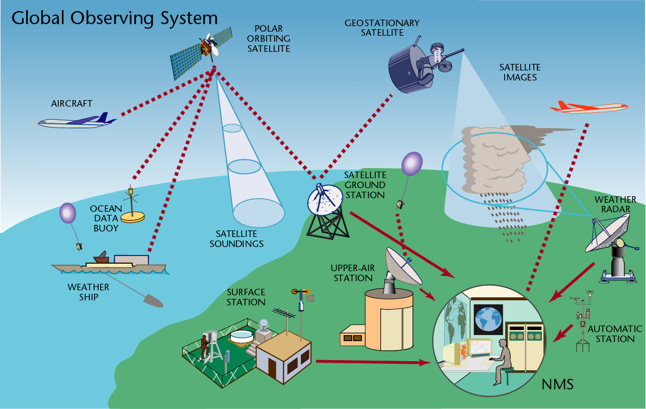
The Global Observing System (GOS), coordinated by WMO, comprises components which make use of a number of different radio applications.
Spaceborne passive sensing of the Earth’s surface and atmosphere has an essential and increasing importance in operational and research meteorology, in particular for mitigation of weather and climate related disasters, and in the scientific understanding, monitoring and prediction of climate change and its impacts.
The impressive progress made in recent years in weather and climate analysis and forecasts, including warnings for dangerous weather phenomena (heavy rain, storms, cyclones) that affect all populations and economies, is to a great extent attributable to spaceborne observations and their assimilation in numerical models.
Spaceborne passive sensing for meteorological applications is performed in bands allocated to the Earth exploration satellite (passive) and meteorological satellite service. Passive sensing requires the measurement of naturally occurring radiations, usually of very low power levels, which contain essential information on the physical process under investigation.
The relevant frequency bands are determined by fixed physical properties (molecular resonance) that cannot hence be changed or ignored. These frequency bands are, therefore, an important natural resource. Even low levels of interference received by a passive sensor may degrade its data. In addition, in most cases these sensors are not able to discriminate between natural and man made radiations. In this respect, the ITU Radio Regulations (RR footnote 5.340) enables the passive services to deploy and operate their systems in the most critical frequency bands.
It should be stressed that bands below 100 GHz are of particular importance, as they provide an "allweather" capability since clouds are almost transparent at these frequencies.
Several geophysical parameters contribute, at varying levels, to natural emissions, which can be observed at a given frequency which presents unique properties. Therefore, measurements at several frequencies in the microwave spectrum must be made simultaneously in order to isolate and to retrieve each individual contribution, and to extract the parameters of interest from the given set of measurements. Passive frequency bands should hence be considered as a complete system. Current scientific and meteorological satellite payloads are not dedicated to one given band but include many different instruments performing measurements in the entire set of passive bands.
It should also be noted that full global data coverage is of particular importance for most weather, water and climate applications and services.
Also of great importance is the availability of sufficient and well protected Earth exploration and meteorological satellite frequency spectrum for telemetry/telecommand as well as for satellite downlink of the collected data.
The meteorological aids (MetAids) radiocommunication service is used for meteorological and hydrological observations and exploration, and provides the link between an in situ sensing system for meteorological variables and a remote base station. The in situ sensing system, commonly called radiosonde, is in most cases carried by a weather balloon. Alternatively, it may be falling through the atmosphere on a parachute after deployment from an aircraft or meteorological rocket. The base station may be in a fixed location, or mounted on a mobile platform as used in research or defence operations. Base stations are also carried on ships and on hurricane watch or research aircraft.
Additionally, meteorological radars and windprofiler radars perform an important part in the meteorological observation processes. Radar data are input to the Numerical Weather Prediction models for nowcasting, short-term and medium-term forecasting. There are currently about one hundred windprofiler radars and several hundred meteorological radars worldwide that perform precipitation and wind measurements and play a crucial role in the immediate meteorological and hydrological alert processes. Meteorological radar networks represent the last line of defence against loss of life and property in flash flood or severe storms events, such as in several recent widely publicized dramatic cases.
The issues related to the above radio spectrum requirements and operation are addressed within WMO by the Steering Group on Radio Frequency Coordination (WMO SG-RFC). Within Europe, more than 20 National Meteorological Services and other relevant organizations have established the EUMETFREQ programme in order to coordinate their frequency protection activities. Frequency management and protection are particularly important for the WMO Space Programme, and Space Agencies have established the Space Frequency Coordination Group (SFCG) to coordinate their activities in this respect.
The fifteenth World Meteorological Organization Congress (Geneva, May 2007), attended by 163 Member countries, confirmed serious concern at the continuous threat to radio frequency bands allocated for meteorological and related environmental systems expressed by the Fourteenth Congress and adopted Resolution 4 (Cg-XV) – Radio frequencies for meteorological and related environmental activities – in which WMO’s 188 Member states and territories are urged to make all efforts to do their utmost to ensure the availability and protection of suitable radio frequency bands required for meteorological and related environmental operations and research. |

|
|
|
|
|