|
|||
|
|
|||
|
|
|
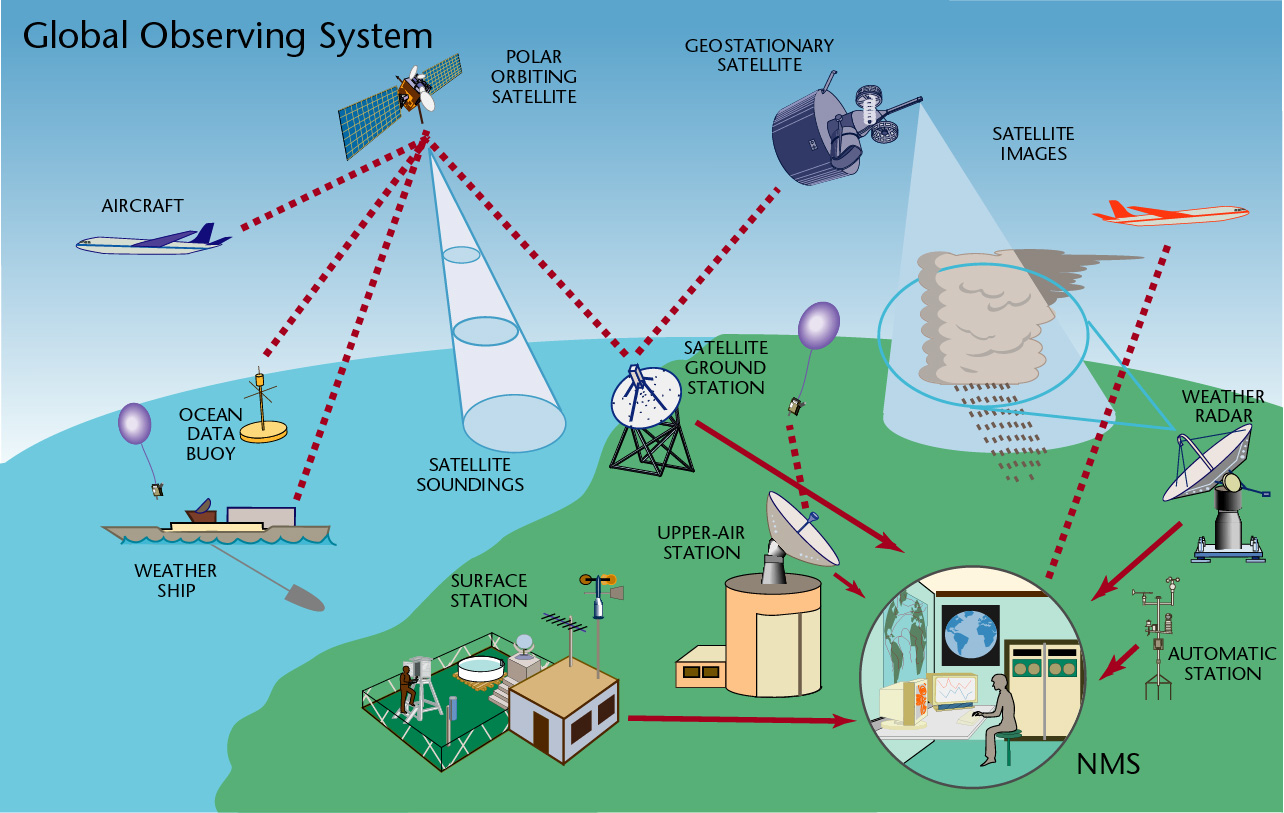
Observation components of the Global Observing SystemSurface observations — Upper-air observations — Marine observations — Aircraft-based observations — Satellite observations — Weather Radar observations — Other observation platforms
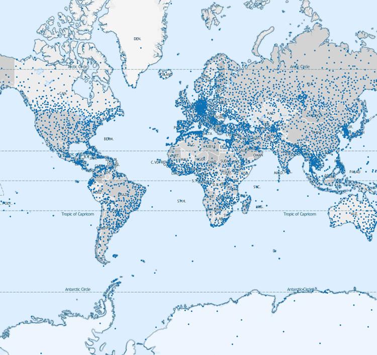
The backbone of the surface-based sub-system continues to be about 11,000 stations (see list in OSCAR/Surface) on land making observations at or near the Earth’s surface, at least every three hours and often hourly, of meteorological parameters such as atmospheric pressure, wind speed and direction, air temperature and relative humidity.
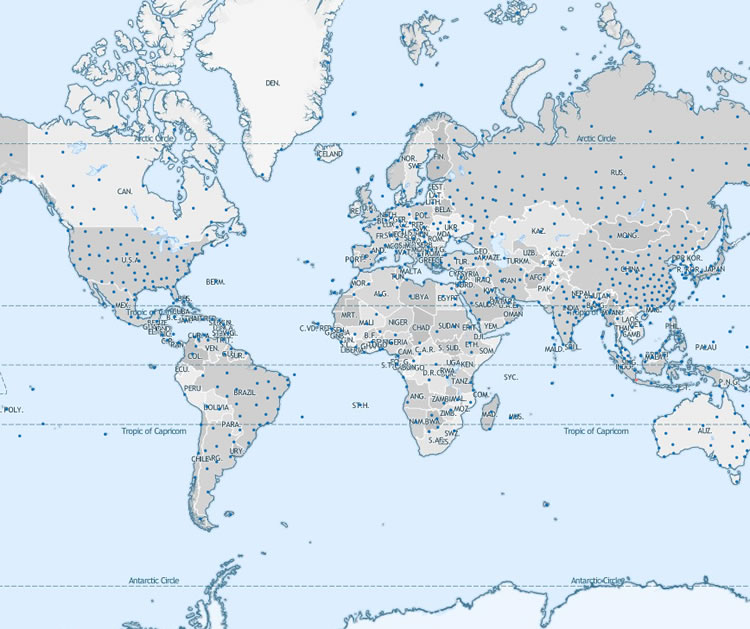
From a global network of about 1,300 upper-air stations, radiosondes, attached to free-rising balloons, make measurements of pressure, wind velocity, temperature and humidity from just above ground to heights of up to 30km. Over two thirds of the stations make observations at 0000UTC and 1200UTC. Between 100 and 200 stations make observations once per day. In ocean areas, radiosonde observations are taken by about 15 ships, which mainly ply the North Atlantic, fitted with automated shipboard upper-air sounding facilities (ASAP). A subset of upper-air stations comprise the GCOS Upper-air Network (GUAN). For the list and details about upper-air stations see the OSCAR/Surface database. Mapbelow shows the list of Upper Air stations as of November 2017.
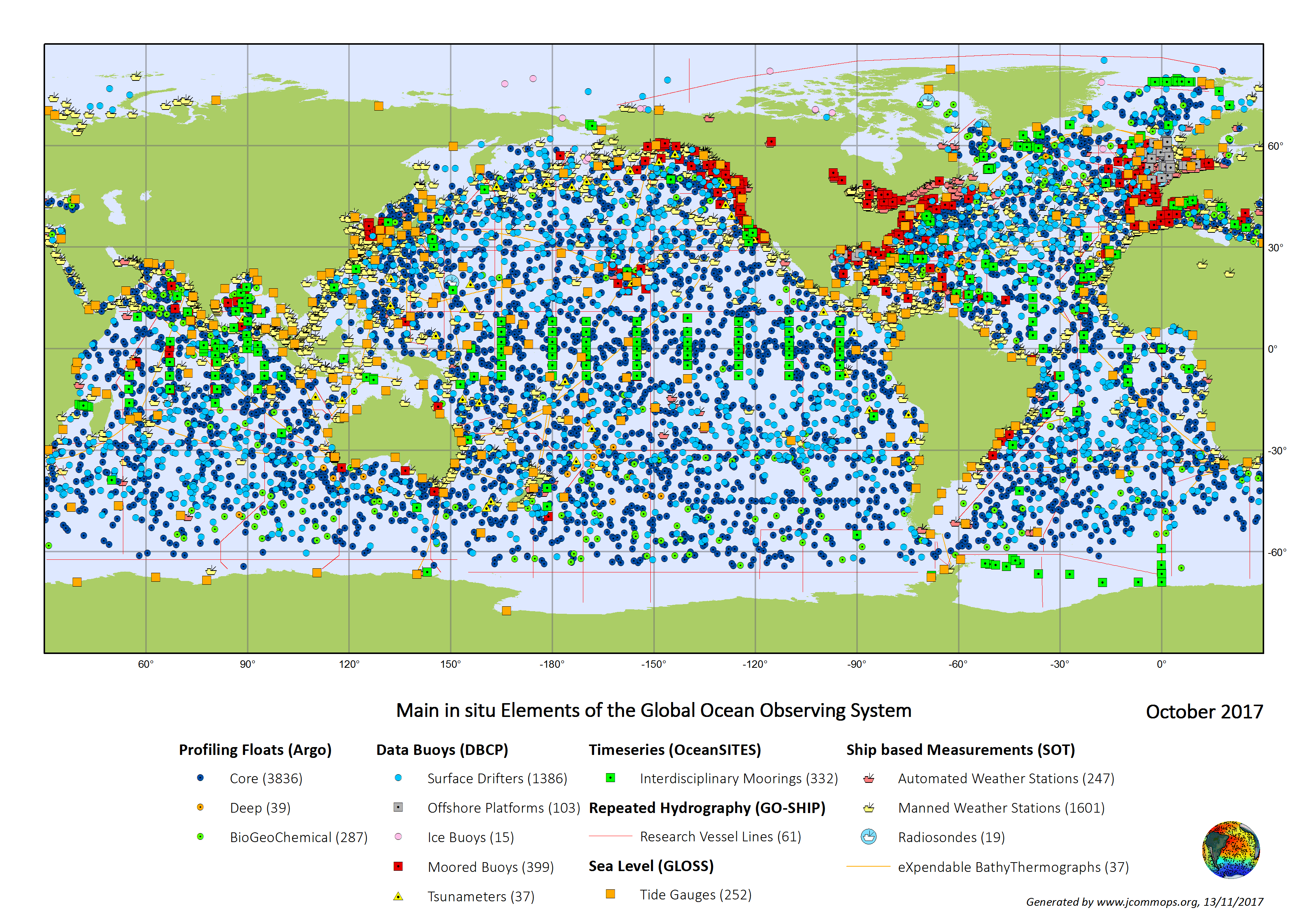
Remote surface-based instruments are also used operationally for upper air observations, e.g. wind profiler radars, acoustic wind sounders (SODAR), and Doppler wind lidars as well as ceilometers (visibility, cloud base and aerosols). In addition, upward-looking ground-based instruments for the remote sensing of tropospheric temperature and humidity profiles are carried out using microwave radiometers, radio-acoustic sounding systems (SODAR-RASS) and Raman-lidar as well as differential absorption lidar. Integrated water vapour is also estimated from ground-based GNSS stations and used operationally within numerical weather prediction. These remote sensing techniques are especially useful for making observations at times between balloon-borne soundings and for filling gaps at locations without regular radiosonde ascents. They thus have great potential to be a valuable part of integrated networks. Over the oceans the GOS relies - in addition to satellites - on ships, moored and drifting buoys and stationary platforms. Observations made by ships recruited under the WMO Voluntary Observing Ship (VOS) Programme, comprise much the same variables as at surface land stations with the important additions of sea surface temperature, wave height and period. The number of observing ships is around 4,000. About 1000 of them report observations every day. The operational drifting buoy programme comprised of about 1,200 drifting buoys provides over 27,000 sea surface temperature per day. Half of the drifters also report sea level pressure providing about 14,000 reports per day. These ships and buoys are part of the WMO Marine Programme, which maintains lists of ships and observing standards. Moreinformation on marine observations can be found here.
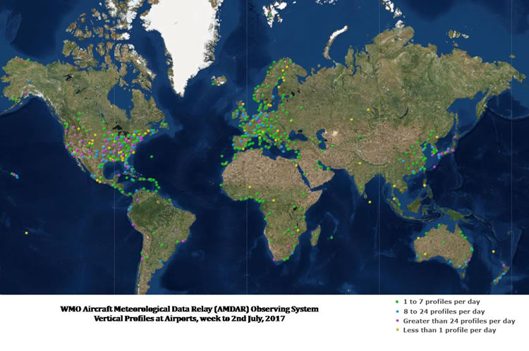
In collaboration with ICAO and commercial and other airlines, aircraft-based observations are received from over 3000 aircraft, providing reports of pressure, winds, temperature, humidity, turbulence and other parameters during flight. The Aircraft Meteorological Data Relay (AMDAR) system makes high quality observations of winds and temperatures at cruising level as well as at selected levels in ascent and descent. The amount of data from aircraft has increased dramatically during recent years - from 78,000 observations per day in 2000 to more that 800,000 observations per day in 2017. Providing great potential for measurements in places where there is little or no radiosonde data, these systems are making a major contribution to the upper-air component of the GOS. See the WMO Aeronautical Programme for more on aviation meteorology.
The Environmental Observation Satellite network included three operational near-polar-orbiting satellites and six operational geostationary environmental observation satellites as well as several Research and Development satellites (See WMO's Space Programme for current information). Polar orbiting and geostationary satellites are normally equipped with visible and infra-red imagers and sounders, from which one can derive many meteorological parameters. Several of the polar-orbiting satellites are equipped with sounders instruments that can provide vertical profiles of temperature and humidity in cloud free areas. Geostationary satellites can be used to measure wind velocity in the tropics by tracking clouds and water vapour. Satellite sensors, communications and data assimilation techniques are evolving steadily so that better use is being made of the vast amount of satellite data. Improvements in numerical modelling in particular, have made it possible to develop increasingly sophisticated methods of deriving the temperature and humidity information directly from the satellite radiances. Research and Development (R&D) satellites comprise the newest constellation in the space-based component of the GOS. R&D missions provide valuable data for operational use as well as for many WMO supported programmes. Instruments on R&D missions either provide data not normally observed from operational meteorological satellites or improvements to current operational systems. Weather radars have been used in the detection of precipitating water droplets and the derivation of rainfall rates within clouds (Cumulonimbus and Nimbostratus) since the 1950s. Doppler radars are used extensively as part of national, and increasingly of regional networks, mainly for short range forecasting of severe weather phenomena. Particularly useful is the Doppler radar capability of making wind measurements and estimates of rainfall amounts. More recently, dual polarized weather radars have been developed that enable more accurate determination of precipitation types and sizes. GOS also includes solar radiation observations, lightning detection, and tide-gauge measurements. |
|||||||||
| ©2016 World Meteorological Organization, 7bis, avenue de la Paix, CP No. 2300, CH-1211 Geneva 2, Switzerland - Tel.: +41(0)22 730 81 11 - Fax: +41(0)22 730 81 81 | ||||||||||