|
|
|
| The Global Telecommunication System (GTS) |
|
The Global Telecommunication System (GTS) is defined as: "The co-ordinated global system of telecommunication facilities and arrangements for the rapid collection, exchange and distribution of observations and processed information within the framework of the World Weather Watch."
|
| WMO No 49 Technical Regulations |
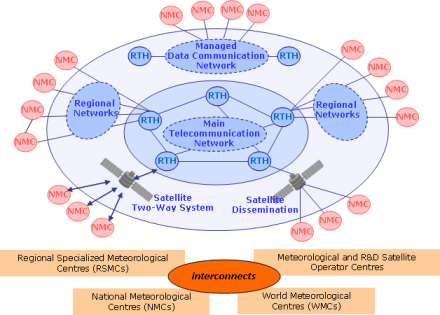 |
| FIGURE 1 - Structure of the Global Telecommunication System |
WMO's Global Telecommunication System (GTS) is the communications and data management component that allows the World Weather Watch (WWW) to operate through the collection and distribution of information critical to its processes. It is implemented and operated by National Meteorological Services of WMO Members and International Organizations, such as ECMWF and EUMETSAT. As decided by Congress and the Executive Council the GTS also provides telecommunication support to other WMO programmes, facilitating the flow of data and processed products to meet requirements in a timely, reliable and cost-effective way, ensuring that all Members have access to all meteorological and related data, forecasts and alerts. This secured communication network enables real-time exchange of information, critical for forecasting and warnings of hydrometeorological hazards in accordance with approved procedures.
The GTS has a hierarchical structure on three levels:
The Main Telecommunication Network (MTN), linking together three World Meteorological Centres (WMCs) (Melbourne, Moscow and Washington) and 15 Regional Telecommunication Hubs (RTHs) (Algiers, Beijing, Bracknell, Brasilia, Buenos Aires, Cairo, Dakar, Jeddah, Nairobi, New Delhi, Offenbach, Toulouse, Prague, Sofia and Tokyo) see Figure 1. This core network has the function of providing an efficient, rapid and reliable communication service between the Meteorological Telecommunication Centres (MTCs).
The Regional Meteorological Telecommunication Networks (RMTNs) is an integrated network of circuits covering the six WMO regions - Africa, Asia, South America, North America, Central America and the Caribbean, South-West Pacific, Europe and Antarctic - and interconnecting the MTCs thus ensuring the collection of observational data and regional selective distribution of meteorological and other related information to Members. Until the integrated network is completed, HF-radio-broadcasts may be used in order to meet the requirements of the WWW for the dissemination of meteorological information.
The National Meteorological Telecommunication Networks (NMTNs) enable the National Meteorological Centres (NMCs) to collect observational data and receive and distribute meteorological information on a national level.
Satellite-based data collection and/or data distribution systems are also integrated in the GTS as an essential element of the global, regional and national levels of the GTS. Data collection systems operated via geostationary or near-polar orbiting meteorological/environmental satellites, including ARGOS, are widely used for the collection of observational data from Data Collection Platforms. Marine data are also collected through the International Maritime Mobile Service and through INMARSAT. International data distribution systems operated either via meteorological satellites such as the Meteorological Data Distribution (MDD) of METEOSAT, or via telecommunication satellites, such as RETIM or FAX-E via EUTELSAT are efficiently complementing the point-to-point GTS circuits. Several Countries, including Argentina, Canada, China, France, India, Indonesia, Mexico, Saudi Arabia, Thailand and the USA, have implemented satellite-based multi-point telecommunication systems for their national Meteorological Telecommunication Network.
The MTCs function is to accommodate the volume of meteorological information and its transmission within the required time limits for global and interregional exchange of observational data, processed information and any other data required by its Members. Regional Telecommunication Hubs (RTHs) on the MTN perform an interface function between the RMTNs and the MTN.
The GTS is an integrated network of surface-based and satellite-based telecommunication links of point-to-point circuits, and multi-point circuits, interconnecting meteorological telecommunication centres operated by countries for round-the-clock reliable and near-real-time collection and distribution of all meteorological and related data, forecasts and alerts. This secured communication network enables real-time exchange of information, critical for forecasting and warning of hydrometeorological hazards.
WMO GTS is the backbone system for global exchange of data and information in support of multi-hazard, multipurpose early warning systems, including all meteorological and related data; weather, water and climate analyses and forecasts; tsunami related information and warnings, and seismic parametric data. WMO is building on its GTS to achieve an overarching WMO Information System (WIS), enabling systematic access, retrieval, and dissemination and exchange of data and information of all WMO and related international Programmes.
|

|
|
|
|
|


