| Hydrology and Water Resources Programme (HWRP) |
 |
Programmes > HWRP > Flood forecasting
Flood forecasting and early warning for Zambezi River basin
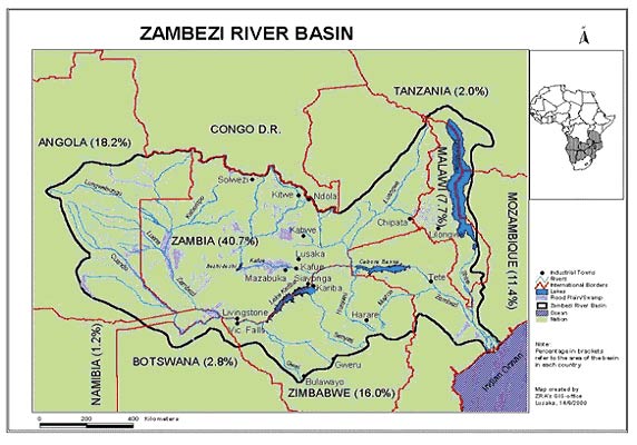
The Zambezi River is the longest and largest river in the Southern Africa sub-region. Its basin is shared by Angola, Botswana, Malawi, Mozambique, Namibia, Tanzania, Zambia and Zimbabwe. There are two large reservoirs in the Basin – the Kariba and Cahora Bassa dams. Water releases from these reservoirs can exacerbate flooding in downstream countries, especially when heavy rainfalls or tropical cyclone events coincide with above-normal inflows to the reservoirs. Almost every year, Zambezi River floods claim lives and cause grave economic losses, thus severely impeding overall socio-economic development in the Basin.
WMO, in collaboration with USAID/OFDA, are developing a Strategy for Flood Forecasting and Early Warning in the Zambezi Basin. The proposed project is intended to assess the capacity for flood forecasting and early warning in the countries in the Zambezi River Basin and formulate a consensus strategy. Current WMO initiatives such as the Regional Flash-Flood Guidance System – Southern Africa component (SARFFG System) and SADC-HYCOS project will complement the project objectives.
A regional consultation meeting was organized from 1st to 3rd December 2009 in Maputo, Mozambique, as the first activity of the project, with the objectives to bring together all interested parties to agree on a framework for flood forecasting and early warning system for the Zambezi Basin, to gather necessary information from the countries in the Zambezi Basin to support the development of the Flood Forecasting and Early Warning (FFEW) Strategy in the Zambezi Basin and decide on the implementation of a Demonstration Project. Directors of NMHSs and other experts attending the consultation meeting presented country papers on the status of flood forecasting in the Zambezi Basin. The experts highlighted countries’ needs and challenges facing the establishment of basin wide flood forecasting and early warning system and the opportunities in the region to develop an effective flood forecasting and early warning system. Invited experts from regional and international organizations presented different activities undertaken or planned to be undertaken by their organizations related to flood forecasting in the Zambezi Basin.
Based on the discussions at the meeting a regional consensus on development of a flood forecasting and early warning system for the Zambezi Basin based on a strategy was achieved. The process for confidence building among countries in the Zambezi River Basin for real-time sharing of flood information was initiated and road map for activities to be implemented under the project until 2012 was established.

