WORLD METEOROLOGICAL ORGANIZATION
COMMISSION FOR BASIC SYSTEMS
MEETING OF THE INTER-PROGRAMME TASK TEAM ON
FUTURE WMO INFORMATION SYSTEMS
FINAL REPORT
MELBOURNE, 1 - 5 NOVEMBER 1999
CONTENTS
Pages |
|
Agenda |
ii |
General summary of the work of the session |
1 - 13 |
Annexes |
14 - 16 |
List of participants |
17 |
AGENDA
1. ORGANIZATION OF THE MEETING
1.1 Opening remarks
1.2 Adoption of the agenda
1.3 Working arrangements
2. DEVELOPMENT OF A WMO DATA MANAGEMENT GUIDE
3. REVIEW OF REQUIREMENTS FOR WMO INFORMATION SYSTEMS
4. REVIEW OF EMERGING TECHNOLOGIES APPLICABLE TO WMO INFORMATION SYSTEMS
5. PRIORITIES FOR INFORMATION SYSTEM REQUIREMENTS
6. OVERALL VISION OF FUTURE WMO INFORMATION SYSTEMS
7. PLANS FOR FURTHER DEVELOPMENT OF AN INFORMATION SYSTEM STRATEGY
8. CLOSURE OF THE MEETING
1. ORGANIZATION OF THE MEETING
1.1 Opening remarks
1.1.1 A meeting of the Inter-programme task team on future WMO information systems opened at 0900 on Monday 1 November 1999 at the Yarra Valley Conference Centre outside of Melbourne, Australia. Dr G. Love (Australia) opened the meeting and welcomed the participants to Australia. He also chaired the meeting. Mr D. McGuirk welcomed the participants on behalf of the Secretary-General and outlined the objectives of the meeting. He noted the primary purpose was to develop a strategic overview of integrated information systems and services and to review the structure and the operational organization of the GTS to gain maximum benefit from modern data-communication techniques and services.
1.2 Adoption of the agenda
The meeting adopted the agenda as reproduced in the beginning of this report.
2.
DEVELOPMENT OF A WMO DATA MANAGEMENT GUIDE (agenda item 2)2.1 The third inter-programme data management coordination meeting (Washington, March 1999) discussed development of a WMO Data Management Guide and agreed that the most effective action would be to develop a broad outline or overview document on data management that would apply to all Commissions. Australia had kindly volunteered to review the World Weather Watch, Hydrological and draft Climatological guides on data management and to produce a draft WMO guide which was to be reviewed at the current meeting. The experts recommended that each commission review their own requirements and define (or extract) best practices and performance indicators that could be included in the guide. They emphasised that the guide should focus on the information management level rather than on data management (such as observing practices, etc.). The experts were grateful to note that Australia volunteered to refine the work done to date and to produce a draft for internal review by January 2000 and external review by March 2000.
3. REVIEW OF REQUIREMENTS FOR WMO INFORMATION SYSTEMS (agenda item 3)
3.1 CBS, at its recent extraordinary session (Karlsruhe, October 1998) reiterated its commitment to ensure that the Basic Systems meet the requirements of all WMO and related international programmes. The president of CBS invited the presidents of each of the other Technical Commissions to identify the information system requirements of their respective programmes and to participate in the effort to plan for future WMO information systems. Experts attended the meeting representing CBS, CCl, JCOMM, CHy, CAgM, and CAeM. Each made brief presentations, which are summarised in the following paragraphs.
Commission for Aeronautical Meteorology
3.2 James Travers briefed the meeting on the CAeM perspective. He noted that the World Weather Watch (WWW) has been a fundamental part of aeronautical meteorology and will continue to be so. NWP models operated as a part of the WWW have had a profound impact on aviation, particularly international aviation.
3.3 Data requirements for aeronautical meteorology depend on the varied responsibilities of the meteorological service providers within the World Area Forecast System.
3.4 There will continue to be increasing volumes of real time data available especially from automated systems, e.g. AMDAR. There will also be increased demand for meteorological products, e.g. higher resolution NWP data, to service aeronautical meteorology. Information systems of the future need to allow for this. It must also be remembered that, while data needs to flow globally, data gathered locally needs to be available locally for use by local meteorologists.
Commission for Agricultural Meteorology
3.5 Russell Stringer, representing CAgM, noted that the information system requirements of agricultural meteorology overlap many of those for other activities. Fundamental requirements include: rapid and reliable availability of current observational data to support forecast/warning and public information services; global NWP model information, to support forecast/warning services and for embedding regional and local models; satellite data; historical climate data and climate prediction information. The timeliness and delivery requirements range from immediate delivery, to less urgent routine transfer initiated by either the sender or recipient, to ad hoc access initiated by the recipient.
3.6 A number of specific requirements of agricultural meteorology may be described with respect to data collection, transmission and processing. Some specific data collection requirements include: station network density, representativeness and reporting program which adequately covers key agricultural sites and regions, including the collection of data which for many reasons does not currently reach the GTS; observation and collection of elements, additional to the regularly observed weather and climate elements, of interest to agriculture; and effective quality control, particularly with respect to the expanding use of AWS, including greater use of metadata. Some specific data transmission requirements include: more flexibility in real time reporting codes to allow inclusion of additional meteorological elements of interest to agriculture; standardised and stable reporting codes/formats to support multidisciplinary users in fields such as agronomic modelling and food security. Some specific data processing requirements include data integration for maximum utility of the diverse range of meteorological data types of interest to agriculture and data completeness to support applications, including derived data and synthetic data.
Commission for Basic Systems
3.7 Geoff Love reviewed the data management activities conducted by CBS. This review considered several aspects of data management:
Data Exchange
3.8 It was noted that the Global Telecommunications System (GTS) is the primary WMO system for data and information exchange, and that the system continues to evolve to meet emerging needs. The most significant recent changes involve the use of Internet protocols on the GTS and the increasing capacity of many circuits. Significant problems still remain with the state of the implementation in some developing countries. Furthermore, for a variety of reasons it is not the system of choice for all Commissions when addressing their communication requirements.
Data Quantity and Quality Monitoring
3.9 It was noted that CBS conducts quantity monitoring on the GTS every October and more targeted Special MTN Monitoring from time-to-time. While these exercises are useful, particularly the Special MTN Monitoring, they do not enable managers to rapidly identify and respond to data losses.
3.10 Data quality monitoring was seen as a significant success of CBS. With the spread of lead centres undertaking the activity globally there is in place a commitment to continuous monitoring and improvement of data quality on the part of all Members.
Data Representation
3.11 It was noted that the development of data representation forms by CBS was an important and difficult task. Members are finding it difficult to provide experts and significant work needs to be done to migrate fully away from the traditional character codes to the more flexible table driven codes such as CREX, BUFR, and GRIB.
Commission for Climatology
3.12 Jim Laver presented a summary of information system requirements for the Commission on Climatology (CCl). He noted that operational climate monitoring and prediction responsibilities at national meteorological centres and at multinational centres (e.g., DMCs) are rapidly growing in number and in operational commitments, in the volume of data sets and products required and generated, and in requirements for increased capacity and flexibility in communication. The current and future information requirements for performing operational climate monitoring and prediction represent a substantial addition to existing information requirements. New and innovative ways to generate, transmit, modify and critique information, as well as educate users regarding climate products, are required to: link climate variations with weather patterns and extremes; to improve climate prediction capabilities; and to keep pace with modern technology and the demands of a broad spectrum of new and diverse users of climate applications in the public and private sectors.
3.13 Some examples of information requirements for operational climate monitoring and prediction services follow:
- Information (data and products) which provide a thorough understanding of historical, recent, current and projected regional and global climate and weather variations over days, weeks, seasons, and decades. This includes, and is significantly more than, what is required for weather monitoring and forecasting.
- New volumes of climate data and products generated for real-time transmission. Some examples include: discussions and graphical depictions which monitor and predict threats from extreme temperature, rainfall, drought, wind and storminess patterns; graphical depictions of atmospheric and oceanic interactions which link weather and climate variability; ensemble climate model prediction output; ocean monitoring, diagnostic and prediction products.
- Real-time coordination of complex products with external organizations, e.g., emergency managers, health interests, agriculture interest; simultaneous telephone conferencing with Internet browsing; dependable and rapid e-mail and "chat room" flow; real-time product generation/interaction by two or more remotely located centers.
- Updated, on-line training materials, tutorials, "frequently asked questions."
- Direct connection to applied research components, which help develop new, operational climate products and applications for users, often by accessing real-time data and products for rapid response, testing and development.
3.14 Estimating the volume of new climate data and products is difficult and seems almost irrelevant considering the pace of development. Nearly any volume is no longer a problem in many countries – disk space and communication speed continue to advance and get cheaper. For other countries nearly any volume, and continuous communication at even low speeds, are consistent problems.
3.15 Local processing software, "standardisation" for data bases, statistical packages, display formats, and programming languages are issues, especially since many centres are going in different directions.
3.16 Mary Voice of the Australian National Climate Centre described the needs of the climate community from the perspective of a data centre. She noted that climate needs:
- A combination of private and public access to data and products
- A subscription capability for routine products and capacity to request ad hoc and quasi-routine products
- Notification of the availability of some critical products
- The capability to combine standard hydrological, marine and climate data products and information more easily than in the past – this would be facilitated through metadata and format standards
Commission for Hydrology
3.17 Bruce Stewart, representing CHy, informed the meeting of the current status and future requirements of the WMO Hydrology and Water Resources Programme. Currently, there is limited hydrological data and/or information transferred between member countries of WMO. The main hydrology related "information" systems in operation within WMO are largely hard copy based in the form of Technical Regulations, the Guide to Hydrological Practices and Technical and Operational Hydrology Reports. Computer based information systems include INFOHYDRO (Excel Spreadsheet) which provides information on the agencies that collect hydrological data and their networks and the Hydrological Operational Multipurpose System (HOMS) (limited information can be accessed via the Internet) which provides access to technology, software, guidelines and manuals. Plans are in place to increase access to information sources such as the above using the Internet. Future requirements for the movement of hydrological information will include data transferred under Resolution 25 of the 13th WMO Congress (1999), the Exchange of Hydrological Data and Products, and data to be transferred within the World Hydrological Cycle Observing System (WHYCOS). Also, consideration should be given to improving the methods of transfer of hydrological data into and out of the Global Runoff Data Centre (GRDC). In this regard, a methodology for moving hydrological data in (near) real time into the GRDC to assist in the provision of global hydrological products should also be considered.
3.18 The GTS is being proposed for use in the collection of hydrological data within the WHYCOS projects. However, alternative, less expensive and more accessible methods for product and data delivery are being used and need to be further considered in order for users (including hydrological services) to gain effective and efficient use of the data collected.
Joint WMO/IOC Technical Commission for Oceanography and Marine Meteorology
3.19 Joe Elms informed the meeting that from the perspective of the Joint WMO/IOC Technical Commission for Oceanography and Marine Meteorology (JCOMM), telecommunications is the critical element to success. The Inmarsat satellite system of telecommunications (approximately 99% efficient) used to transmit and receive weather information under the Global Maritime Distress and Safety System is a significant improvement. The next major step is to control the quality, distribution, and cost of the observations. Improving global coverage of data receipts and ensuring data quality are important requirements especially where coders and decoders are involved (e.g. specialised coders such as BUFR). Improving metadata is essential for using both historical and contemporary observations, efforts should include expanding the contents of WMO Pub. No. 47 and in digitising those volumes not currently in digital forms. Metadata should also be collected in an established format for buoys and other ocean observing platforms. Included should be documenting the chronology of WMO FM codes and data exchange formats and in developing an international standard format for digitising and archiving historical marine data. Finally, he felt that JCOMM needed to seek incentives to encourage participation in these activities.
3.20 The meeting noted that JCOMM had agreed that it needed to begin a process in which oceanography and marine meteorology would transition from the existing largely unconnected set of monitoring, data management and service activities to a fully coordinated and integrated system. This transition process, however, must be incremental and evolutionary, not revolutionary. The transition process should selectively broaden and modify the tasks of existing mechanisms towards an agreed new structure. The integrated work plan includes:
- Coordinating and optimising existing observing networks, and generally enhancing the quantity and quality of available ocean data in support of diverse user requirements
- Data exchange procedures and formats, including enhanced and standardised use of Internet technology and facilities
- Preserving the current work and priorities relating to operational marine forecasting and services, while at the same time addressing urgent requirements for ocean data and climate
4. REVIEW OF EMERGING TECHNOLOGIES APPLICABLE TO WMO INFORMATION SYSTEMS (agenda item 4)
4.1 The experts reviewed several examples of current and emerging technologies that could have a significant impact on development of a future WMO information system.
Unidata IDD
4.2 Russ Rew presented information about Unidata’s Internet Data Distribution (IDD) system. First he provided some background on Unidata, which is operated by the University Corporation for Atmospheric Research to enable universities to acquire and make use of atmospheric and related data. The IDD is a national scale, distributed, collaborative, near real-time, event-driven application of the Internet and TCP/IP protocols that currently delivers data continuously to about 160 universities and research institutions for use in research and education. It has been in operation since 1994, when it began disseminating real-time weather data to 20 universities. The system has no data centre; instead, streams of data products are injected into the IDD routing trees from multiple source locations. Dr Rew presented typical daily volumes for each of the most widely used IDD data streams, which include the observational data products and model output fields from the NOAAPORT National Weather Service Telecommunications Gateway, radar data, satellite data, wind profiler data, airline data, and lightning data. He also discussed new data streams that will soon be available from other sources.
4.3 The IDD system is implemented with Unidata’s freely available Local Data Manager (LDM) software, designed for Unix systems. The system works by relaying products through a routing tree of LDM nodes at universities. An event-driven architecture is used rather than polling or scheduled delivery to assist in timely delivery of products. Mechanisms for enhancing reliability include use of TCP, a product queue at each relay node that typically holds an hour’s worth of products, and the provision of back-up servers to continue delivery through short network outages. Additional features include data on individual product latencies, duplicate product detection and elimination, use of pattern matching for local filing and decoding of products, host based security, and ability to change configuration details while the system is running. Current limitations of the system include limits on product queue of about 2 Gigabytes, manual maintenance of routing configurations, lack of support for product priorities, and dependence on Unix operating system features. The IDD system is working satisfactorily today, but needs some enhancements to meet growing data volumes and would be more widely useful if it were independent of operating system. Further information can be found at http://www.unidata.ucar.edu/projects/idd/ and http://www.unidata.ucar.edu/packages/ldm/.
EMWIN
4.4 Kevin Alder made a presentation on EMWIN (Emergency Managers Weather Information Network). He noted that the implementation of EMWIN in the Southwest Pacific has resulted in a very cost-effective method for the reception of real-time operational data and products by National Meteorological Services in that region. For many years, these Services had limited access to meteorological data and products due to a lack of suitable communications facilities. Most Services relied on the Aeronautical Fixed Telecommunication Network (AFTN) prior to 1997 for this service.
4.5 Approximately US$1500 is sufficient to purchase the necessary hardware to receive the EMWIN data stream broadcast on GOES-10. This gives the Meteorological Service access to warnings, advisories, forecasts and a range of graphics for their country and the surrounding area. Countries in the Southwest Pacific with EMWIN facilities are Funafuti, Kiribati, Vanuatu, Tonga, Samoa and American Samoa, Nauru, Tokelau, Cook Islands, Fiji, Tahiti and New Caledonia
4.6 Plans are underway to broadcast the EMWIN data stream to the western Pacific using the GOES-7 satellite stationed at approximately 175° E and to increase the range of products available by transmitting GRIB data on the broadcast in the near future. Two-way communications are planned with the development of a remote station up-link utilising the 403 MHz transponders on GOES-7 previously used for DCPs. This may be used to replace some of the variety of systems currently used to insert observations into the GTS.
Naval Research Laboratory
4.7 Ted Tsui of the U.S. Naval Research Laboratory made a presentation on some of the Navy’s information systems relevant to WMO. He suggested that, in developing a distributed request/reply system for non-real-time data, the "data warehousing" idea should be considered. A mid-layer software suite between clients and servers can be developed to act as a consolidated product catalogue of the servers, and to serve as a data request dispatcher for the clients. This metadata based three-layer architecture can be used to integrate data servers/centres without dictating the system configuration of individual data centres. However, to make this concept work, a metadata standard must be enforced among data centres. An example of this three-layer architecture implementation can be found in the Master Environmental Library (MEL) project (http://mel.dmso.mil/). MEL dynamically constructs the catalogue from the metadata offered by the data centres, and presents it to the users. Users can order products from this on-line catalogue.
Open GIS Consortium
4.8 David McGuirk made a brief presentation on the International Steering Committee for Global Mapping and the Open Geographic Information System Consortium (OGC) and their efforts to harmonise standards for exchange and application of geospatial information. These rapidly developing technical standards and protocols aim to allow any earth-referenced data to be retrieved via the Internet and combined and overlaid within an application. A high-profile demonstration that illustrated the potential of the technology was held in Washington in September. Interestingly, the demonstration focused on analysis of the impact of a severe weather event, hurricane landfall, and the utility of combining a variety of data from many sources including topography, elevation, land use, transportation corridors and storm surge forecasts. Further information on the demonstration can be found at http://www.opengis.org/wmt/.
4.9 The proposed protocol utilises Extensible Markup Language (XML), which provides a means for text encoding of all data and uses a Document Type Definition or Schema to ensure document and data consistency. XML technologies are becoming widely used on the World Wide Web with over 100 XML derived languages approved in last year. The OGC propose an XML standard encoding of geography to encode geographic features such as property lists (feature attributes), spatial reference systems, and geographic functions (coverages).
4.10 The organisations participating in these groups are primarily focused on protocols that will allow users to easily search, retrieve, access and exploit geospatial information from multiple locations on the WWW. The outcome hopes to enable interoperable web-based exploitation of geodata and sharing of processing services. Although intended for commercial products, these protocols, like TCP/IP and HTTP, will undoubtedly have an impact on meteorological systems within the next few years.
4.11 Mr McGuirk also presented a summary of the ongoing ISO/TC211 process to develop an standard for representation and exchange of metadata for geospatial data.
5. PRIORITIES FOR INFORMATION SYSTEM REQUIREMENTS (agenda item 5)
5.1 The experts reviewed the information systems requirements of the various programmes in light of current and near-term technological capabilities and considered how priorities based on feasibility and cost-effectiveness could be established. They agreed that it was extremely difficult, if not impossible, to specify volume and timeliness requirements for the diverse set of information needed to meet the requirements of all of the programmes. In essence, Members establish links that provide maximum capacity within their financial resources and prioritise data and product flow to ensure operational requirements are met. Accordingly, the experts felt that estimating volume was only relevant for time-critical applications since for many other applications the information transmitted will grow to fill the "pipe" available. Therefore, the experts felt that it was possible to provide useful guidance on a functional vision of a future WMO information system without concise knowledge of volume and timeliness requirements.
6. OVERALL VISION OF FUTURE WMO INFORMATION SYSTEMS (agenda item 6)
6.1 The experts reviewed the current state of WMO information systems and noted it included a number of systems that have been developed to meet a diverse set of requirements. The principle system is, of course, the GTS along with the related data processing and management functions that have been developed to serve the World Weather Watch. They noted that this system has a number of significant strengths.
- It is currently operational and has provided reliable service for many years
- It is secure from outside interference
- It has been designed specifically to meet the requirements of its sponsors, and in particular the exchange of real-time high-priority data
- It is mature and well tested
- It is operated according to well-defined and shared responsibilities
- Its operation is not dependent upon any one vendor or supplier
- Internal development allows it to respond, albeit slowly, to changing requirements
6.2 Other information systems that have been developed to meet the needs of other programmes and Commissions have their own advantages. Given the diversity of these systems it is difficult to provide a concise summary. However, most share a common strength: they have been developed by individual programmes to meet their specific requirements. Thus, the systems are generally focused in their approach and do not suffer from compromises and inefficiencies that can sometimes result from development of generalised systems.
6.3 The experts noted that despite their advantages the current systems suffer from some serious deficiencies. Most importantly, the Basic Systems do not meet the requirements of all WMO Programmes. Problem areas which lead to unmet requirements include:
- volume restrictions which preclude the transmission of satellite imagery, video and other high volume data sets
- inability to rapidly (i.e. routinely near-real-time) identify where data losses are occurring and undertake remedial action
- inability to easily accommodate requirements that include short periods of high volume traffic followed by lengthy periods of low or no traffic
- inability to facilitate information insertion and distribution to public and other clients beyond the meteorological community
- high cost of implementing GTS data collection links, particularly in developing countries
- incomplete nature of the WMO/CBS data representation forms to meet the task of representing and utilising the disparate data types used by all Commissions
- lack of support for a request/reply system providing ad-hoc access to the data and products available for international exchange
- inadequate product identification leading to duplication and uncertainty of content
6.4 Some of the consequences of these shortcomings are development of parallel systems, implementation of bi-lateral links outside of the official GTS, on-going development of new communication systems, and lack of acceptance of WMO data representation forms. The experts felt that unless these problems are addressed quickly, the proliferation of information systems would become a serious problem and lead to duplication of efforts and inefficient use of scarce resources.
6.5 Information systems technology is evolving rapidly and plans for the future must take this evolution in to account. The experts agreed that within 5 years it is likely that the Internet will be available at a relatively low price everywhere and they felt that such an important resource should be utilised wherever it can meet the requirements. The Internet is likely to become the default communication carrier and only where it did not meet the requirements of WMO Programmes would use of private, dedicated circuits be justified. In this regard, use of the Internet could be considered as part of the WMO information system. Nonetheless, the experts agreed that private networks would be required for at least some parts of the WMO network for the foreseeable future.
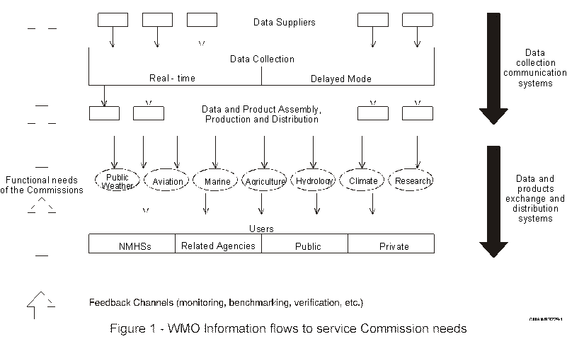
6.6 With these issues in mind, the experts considered development of an overall vision of future WMO information systems at considerable length. A functional overview of the envisioned information flow to meet the integrated needs of all Commissions is shown in Figure 1.
6.7 The meeting agreed that the diverse requirements of the various programmes could be grouped into two general areas: routine delivery of data and products best handled via a store and forward or "push" system, and ad hoc, non routine delivery of data and products through a request-reply or "pull" system.
Store and forward – push systems
6.8 The participants felt that the key to a successful store and forward system is for it to be user-driven. They also felt that while the current GTS is nominally user-driven, the necessity and difficulty of updating multiple routing tables between the recipient and supplier severely constrains its responsiveness to changing requirements, as does the fact that the supplier rather than the recipient updates the tables. The experts also noted that a push system would be much easier to implement and control if the data and products to be delivered were bundled into aggregations that can be selected in whole or in part by relatively simple commands. An expanded header containing, for example, a geographical designator (global, Region or specific country), date, time and product-ID, would facilitate this capability.
6.9 The experts felt that a store and forward system was the most appropriate approach for both the routine collection of observations and the routine dissemination of observations and other products. However, they also considered the collection of observations from the many possible suppliers and dissemination of products from a few suppliers to many recipients to be subtly different problems best met through different logical topologies.
6.10 They felt that a series of perhaps 6 to 10 regional collection centres or data banks might be an appropriate solution for collection of observations. Each supplier, which could be an NMHS, organisation (e.g. ARGOS, ARINC), research project, et cetera, would send its observations to its designated collection centre. The collection centres would then forward the observations to all of the others. The collection of observations would thus be organised into a series of star networks connected by a logical ring between the collection centres at the top. The experts did not believe it was necessary to standardise the physical links and protocols to be used between all of the suppliers and collectors, and recommended that that these instead be decided by bilateral agreement to best match the requirements and capabilities of the parties involved. They noted that this approach is currently used between a number of NMHSs with effective results.
6.11 The experts assumed that the collection centres would usually be located within or closely associated with a centre running a global model or having some other global commitment. However, the proposed architecture does not dictate that this be a requirement.
6.12 Dissemination of products through a store-and-forward based push system implemented as a single layer would, in many cases, require excessive resources at some centres. Therefore product dissemination would probably be best addressed through a multicast or hierarchical store and forward system similar to the current GTS message switches. A system of multiple suppliers and recipients with diverse requirements will probably continue to be best served through a variety of mechanisms. High capability recipients requiring large-volume products could be served by one mechanism while less developed recipients with less demanding requirements could be served by another.
6.13 The experts noted that there have been many developments over the past few years in technologies to routinely collect and disseminate data and products and off-the-shelf multicast and store and forward systems were now available for TCP/IP networks. They felt that these systems might provide a more cost-effective alternative to the current GTS message switches and recommended that their applicability and suitability to WMO requirements be investigated.
Request-reply - pull systems
6.14 The experts felt that pull systems face a number of problems that are not faced by push systems but that one stood out from the others: diversity. The wide range of data and products that could be of potential use creates a need for extensive metadata to describe them. Furthermore, to facilitate identification and location of this information across a number of programmes, the basic descriptive metadata should be searchable according to an agreed standard. The experts noted that there are a number of applicable standards under development and recommended that these activities be closely monitored to ensure WMO can take full advantage of the work being done.
6.15 The other characteristic of request/reply systems is that demand is extremely hard to predict and so it is not always efficient to accommodate this type of traffic on circuits being used for high-priority, routine data exchange. In fact, given the potential for request/reply to overload or slow down the communications networks it was recognised that there may always be a need to separate this traffic from the low volume, high priority real-time data and information.
6.16 Today, the WMO Information System comprises a combination of the private GTS and the public Internet. The GTS consists of a private telecommunication network, satellite broadcast and collection systems and an evolving set of managed network "clouds". It can accommodate a variety of protocols (e.g. X.25 and TCP/IP) and supports the current GTS message switch system as its single most important application. The Internet is playing an increasingly important role, particularly for exchange of non-real-time products, and supports a variety of applications, some of which are pertinent to WMO requirements. Most GTS centres now have links to the Internet and a few GTS circuits have recently been implemented over the Internet.
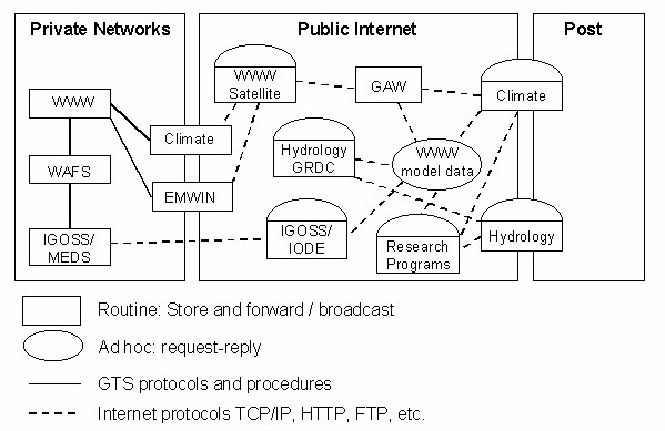
6.17 Considering the current state of the WMO Information System and the overall vision of a future system the experts felt that the figures 2 and 3 highlighted some of the key points:
- There is now limited utilisation of the Internet for operational store and forward applications
- There is limited connectivity between applications developed to serve the needs of the different Commissions
- There are a large number of different applications whose development has not been coordinated making integration of data sets a technically challenging task
- Multidisciplinary application of meteorological, hydrological and oceanographic data is hampered by lack of agreed standards needed to effectively identify, acquire and use all of the relevant data
- Greater use of commercially accepted standards and off-the-shelf hardware could increase the responsiveness and decrease the costs of operating current systems.
Figure 2 - Current WMO Information System
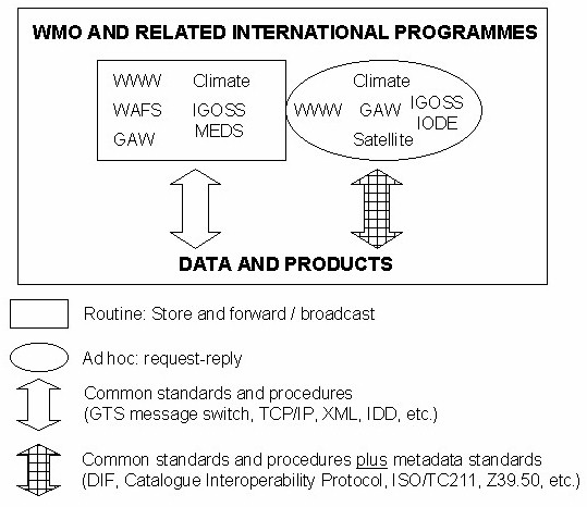
Figure 3 - Future WMO Information System
6.18 The system that the experts would like to ultimately be in place would see WMO coordination of an integrated approach to meeting the requirements of:
- Ad-hoc non-routine applications (e.g. requests for and insertion of non-routine data and products)
- Routine collection of observed data
- Automatic dissemination of scheduled products, both real- and non-real-time
The system would rely upon a combination of public and private networks and would ensure coordinated development and operation of the participating systems through reliance on international protocols and standards and off-the-shelf software.
7. PLANS FOR FURTHER DEVELOPMENT OF AN INFORMATION SYSTEM STRATEGY (agenda item 7)
7.1 The experts realised that the proposed vision had far-reaching implications on the technical and political implementation of the WMO information system. With that in mind they considered steps that should be taken to further develop a WMO information system strategy and to evaluate promising concepts and technologies. They recommended that these activities be targeted to three key areas: request/reply, multicasting and Unidata’s IDD.
7.2 The experts believed that it was important that all of the participating Technical Commissions review and evaluate the proposed vision with a view toward adjustment and further elaboration at a follow-up meeting of the Inter-Commission task team. They felt that attention should be particularly drawn to the exploratory ideas presented in paragraphs 6.10 through 6.13 of this report. Furthermore, the experts requested that the Secretariat seek from the Commissions early comment and advice on the specific actions described below.
Multicasting
7.3 The experts agreed that multicasting technology might be a useful tool for meeting WMO requirements but felt that there was insufficient knowledge of its potential. They recommended that a short 2 to 5 page briefing paper be prepared on multicasting. The paper should describe the technology, identify current proposals for implementation and advise on its potential applicability to WMO information system requirements. Dr Love, noting that the U.S. National Weather Service was in the process of evaluating a proprietary multicasting system, agreed to seek volunteers to prepare such a document.
Internet Data Distribution
7.4 The experts agreed that the Unidata IDD system showed considerable promise and felt its potential should be further evaluated. They recommended that CBS take the lead in establishing an inter-programme expert team to plan and implement a pilot/demonstration project of the information collection and exchange capabilities of the IDD in an environment outside the U.S. academic community. The project should evaluate the feasibility and reliability of using IDD for this purpose along with installation and operational costs. The experience gained could also contribute to a desktop analysis of the scalability of the system. The meeting felt the expert team should include broad inter-commission representation including telecommunications experts along with some experts with experience with the IDD.
7.5 The pilot project should physically test the message switch component of an operational system. This would require operation of an associated display system to demonstrate the system is working (e.g. PC-GRIDS or McIDAS) but successful operation of the display system should not be considered as part of the trial per se. For this reason the simplest system to implement and operate should be used.
7.6 The experts considered possible candidates for pilot implementation of the IDD. Among the proposals considered by the group were collection and distribution of hydrological data, e.g. HYCOS in southern Africa and HYCOS in the south-west Pacific, and dissemination of meteorological data and products in a developing country where a permanent connection to the Internet can be maintained at reasonable cost. A partnership between a developed and developing country was also considered as a possible means to demonstrate and test remote system administration of an IDD system.
7.7 Subject to a successful outcome of the pilot further detailed studies on possible application of the IDD to WMO requirements would be warranted. These studies would necessarily evaluate arrangements for long-term technical support, the role of IDD vis-à-vis the GTS, security and other technical issues and inter-organisational arrangements that must be considered before implementing any system for international operational use.
Request/Reply
7.8 The experts agreed that the most important step toward utilisation of request/reply systems for WMO requirements was specification of standards and recommendation of implementation technologies and protocols. They noted that there is considerable work being done in this area by groups outside of WMO and that it was important that WMO participate to ensure the ongoing work takes WMO requirements into account. They felt this might be best accomplished by participating in on-going development of international standards and monitoring technological developments. The experts noted that although CBS has considered the utility of request/reply solutions for some special requirements (e.g. Distributed Databases), CBS is not the major user nor source of expertise in this area and experts from other Commissions should also participate in this activity. The experts had the following specific recommendations.
- WMO should become a member of the ISO TC/211, which is developing a standard for metadata applicable to geo-spatial data. The Secretariat should acquire a copy of the draft standard and make it available to the experts attending this meeting for review.
- WMO should monitor ongoing technological developments in request/reply systems and the Secretariat should establish an information exchange on these developments on the WMO Internet server.
- The Secretariat should develop a first draft of metadata parameters that are needed to describe meteorological and related data and products and distribute it to the experts attending the meeting and other interested parties for further elaboration and refinement.
8. CLOSURE OF THE MEETING
8.1 The meeting closed on Friday 5 November.
LIST OF PARTICIPANTS
Geoff Love, Chair
Bureau of Meteorology
G.P.O. Box 1289 K
Melbourne, Victoria 3001
Australia
Tel: (+61) 39 669 4217
Fax: (+61) 39 669 4548
E-mail: g.love@bom.gov.auKevin Alder Meteorological Service of New Zealand Ltd
30 Salamanca Road P.O. Box 722
Wellington 6015
New Zealand
Tel: (+644) 472 9379
Fax: (+644) 473 5231
Email: kevin.alder@met.co.nzMiguel Angel Bossi Servicio Meteorologico Nacional
25 de mayo 658
1002 Buenos Aires,
ArgentinaTel: (+54) 11 4514 4223
Fax: (+54) 11 4514 4225
E-mail: mab@meteofa.mil.arJoe Elms
JCOMMNational Climatic Data Centre
151 Patton Avenue
Asheville, NC 28801-5001
USA
Tel: (+1 828) 271 4436
Fax: (+1 828) 271 4328
E-mail: jelms@ncdc.noaa.govAlexander Frolov Hydromet Centre of the Russian Federation
B. Predtechensky 9-13
123242 Moscow
Russian FederationTel: (+7 095) 255 1354
Fax: (+7 095) 255 1582
E-mail: afrolov@mecom.ruJames Laver
CClNational Weather Service NOAA
5200 Auth Road
Camp Springs MD 20446
USA
Tel: (+1 301) 763 8000 ext 7500
Fax: (+1 301) 763 8125
E-mail: jim.laver@noaa.govThomas Potgieter
South African Weather Bureau
Private Bag X097
Pretoria 001
South Africa
Tel: (+27 12) 309 3095
Fax: (+27 12) 323 4518
E-mail: potgiet@cirrus.sawb.gov.zaRuss Rew Unidata Program Office
P.O. Box 3000
Boulder, CO 80307
USA
Tel: (+1 303) 497 8645
Fax: (+1 303) 497 8690
E-mail: russ@unidata.ucar.eduRobert Stanek
Deutscher Wetterdienst
Zentralamt. Frankfurter Str. 135
D-63067 Offenbach
Germany
Tel: (49 69) 8062 2637
Fax: (49 69) 8062 2880
Email: robert.stanek@dwd.deBruce Stewart
CHyBureau of Meteorology
G.P.O. Box 1289 K
Melbourne, Vic. 3001
Australia
Tel: (+61) 39 669 4522
Fax: (+61) 39 669 4725
E-mail: b.stewart@bom.gov.auRussell Stringer
CAgMBureau of Meteorology
G.P.O. Box 1289 K
Melbourne, Vic. 3001
Australia
Tel: (+61) 39 669 4705
Fax: (+61) 39 669 4695
E-mail: r.stringer@bom.gov.auJames Travers
CAeMMeteorological Service of New Zealand Ltd
30 Salamanca Road P.O. Box 722
Wellington 6015
New Zealand
Tel: (+644) 470 0731
Fax: (+644) 470 0801
E-mail: travers@met.co.nzTed Tsui Naval Research Laboratory
7 Grace Hopper Ave
Monterey CA 93943-5502
USA
Tel: (+1 831) 656-4738
Fax: (+1 831) 656-4769
E-mail: tsui@nrlmry.navy.milDavid McGuirk
WMO Secretariat
World Meteorological Organization
7 bis Avenue de la Paix
Case postale No. 2300
CH-1211 GENEVA 2
Switzerland
Tel: (41 22) 730 8241
Fax: (41 22) 730 8021
Email: mcguirk_d@gateway.wmo.chLocal Participants
Bureau of Meteorology
G.P.O. Box 1289 K
Melbourne, Vic. 3001
Australia
Michael Hassett Tel: (+61) 39 669 4224
Fax: (+61) 39 669 4673
E-mail: M.Hassett@bom.gov.auRod Hutchinson Tel: (+61) 39 669 4062
Fax: (+61) 39 669 4760
E-mail: R.Hutchinson@bom.gov.auNeil Plummer Tel: (+61) 39 669 4457
Fax: (+61) 39 669 4760
E-mail: N.Plummer@bom.gov.aBruce Sumner Tel: (+61) 39 669 4349
Fax: (+61) 39 669 1223
E-mail: B.Sumner@bom.gov.auMary Voice Tel: (+61) 39 669 4086
Fax: (+61) 39 669 4515
E-mail: M.Voice@bom.gov.au
ANNEX
LIST OF ACRONYMS
AFTN
Aeronautical Fixed Telecommunication Network
AMDAR
Aircraft Meteorological Data Acquisition and Relay
AWG
CBS Advisory Working Group
AWS
Automatic Weather Station
BUFR
Binary Universal Form for data Representation
CAeM
Commission for Aeronautical Meteorology
CAgM
Commission for Agricultural Meteorology
CBS
Commission for Basic Systems
CBS-Ext.(98)
Extraordinary session of CBS held in 1998
CCl
Commission for Climatology
CEOS
Committee on Earth Observation Satellites
CHy
Commission for Hydrology
CIMO
Commission for Instruments and Methods of Observation
CLIPS
Climate Information and Predictions Services
CREX
Character Representation form for data Exchange
DCP
Data Collection Platform
DIF Directory Interchange Format EC
Executive Council of the WMO
EMWIN
Emergency Managers Weather Information Network
ET
Expert Team (of CBS)
FTP
File Transfer Protocol
GCOS
Global Climate Observing System
GDPS
Global Data Processing System
GIS
Geographic Information System
GOS
Global Observing System
GRDC
Global Runoff Data Centre
GTS
Global Telecommunications System
G3OS
Global Climate, Ocean and Terrestrial Observing Systems
HOMS
Hydrological Operational Multipurpose System
IDD
Internet Data Distribution system
ICT
Implementation/Coordination Team (of CBS)
INFOHYDRO
Hydrological Information Referral Service
ISCS
International Satellite Communication System (USA)
ISO
International Standards Organization
ISO/TC211
ISO Technical Committee 211
JCOMM
Joint WMO/IOC Technical Commission for Oceanography and Marine Meteorology
LDM
Unidata's Local Data Manager
MTN
Main Telecommunications Network (of the GTS)
NMHS
National Meteorological or Hydrological Service
NMS
National Meteorological Service
NWP
Numerical Weather Prediction
OPAG
Open Programme Area Group (of CBS)
OPAG-ISS
Open Programme Area Group on Information Systems and Services
TCP/IP
Transport Control Protocol, Internet Protocol
WAFS
World Area Forecast System
WCRP
World Climate Research Programme
WDC
World Data Centre
WHYCOS
World Hydrological Cycle Observing System
WMO
World Meteorological Organization
WWW
World Weather Watch
XML
Extensible Markup Language