Vision for the Future WMO Information System
1 October 2002
EXECUTIVE SUMMARY
The current WMO information systems have been developed to meet a
diverse set of requirements. The principal system is the GTS along with the related data
processing and management functions that have been developed to serve the World Weather
Watch (WWW). The GTS has a number of significant strengths: it is an operational private
network that mainly provides for the exchange of real-time high-priority data, it is
mature, well tested and operated according to well-defined procedures and shared
responsibilities.
Other information systems that have been developed to meet the needs of
other programmes and Commissions have their own advantages. Given the diversity of these
systems it is difficult to provide a concise summary. However, most share a common
strength: they have been developed by individual programmes to meet their specific
requirements. Thus, the systems are generally focused in their approach and do not suffer
from compromises and inefficiencies that can sometimes result from development of
generalised systems.
The multiplicity of systems operated for different Programmes has,
however, resulted in incompatibilities, inefficiencies, duplication of effort and higher
overall costs for Members. Continuing to develop systems in this uncoordinated manner will
exacerbate these problems and will further isolate the WMO Programmes from each other and
from the wider environmental community. It will increase the difficulty in sharing
information between programmes, which is essential for them to fulfil their requirements.
As a consequence, other organizations, environmental programmes or commercial concerns
might assume responsibility for providing essential data and services and WMO would thus
lose its leadership role.
One option to address these problems might be to enhance the GTS in
such a way as to generalize the services to all Programmes. However, the GTS would still
suffer from well known inherent deficiencies that prevent it from meeting all of the
requirements of WMO Programmes.
Therefore, an alternative approach is proposed: a single coordinated
global infrastructure, the Future WMO Information System (FWIS). It is envisioned that
FWIS would be used for the collection and sharing of information for all WMO and related
international programmes. The relationship between functions performed by FWIS and similar
functions performed by current WMO Programmes is illustrated in the figure. The FWIS
vision provides a common roadmap to guide the orderly evolution of these systems into an
integrated system that efficiently meets all of the international environmental
information requirements of Members.
FWIS relationship to WMO Programmes
FWIS should provide an integrated approach to meeting the
requirements of:
- Routine collection and automated dissemination of observed data and products
("push").
- Timely delivery of data and products (appropriate to requirements)
- Ad-hoc requests for data and products ("pull")
FWIS should be:
- Reliable
- Cost effective and affordable for developing as well as developed Members
- Technologically sustainable and appropriate to local expertise
- Modular and scalable
- Flexible and extensible - able to adjust to changing requirements and allow
dissemination of products from diverse data sources and allow participants to collaborate
at levels appropriate to their responsibilities and budgetary resources
FWIS should also support:
- Different user groups and access policies, such as WMO Resolutions 40/25
- Data as well as network security
- Integration of diverse datasets
Taking into account that information systems technology is evolving
rapidly, FWIS should utilize industry standards for protocols, hardware and software. Use
of these standards will reduce costs and allow exploitation of the ubiquitous Internet and
web services.
The ultimate implementation of FWIS would build upon the most
successful components of existing WMO information systems. It would continue to rely upon the WMO communication system
(initially the GTS) to provide highly reliable delivery of time-critical data and
products.
To clarify the concept of FWIS, three functional components are
defined: National Centres (NC), Data Collection or Product Centres (DCPC)
and Global Information System Centres (GISC). The information and communication
responsibilities of existing WWW and other WMO Programme centres can be mapped into the
corresponding functions within FWIS as illustrated in the table below. It should be noted
that the FWIS functions will be added to the existing functions and responsibilities of
the participating centres, which will continue.
| Current WWW Centres |
FWIS Functions |
NMHS
|
NC |
RSMC
|
DCPC and/or GISC |
WMC
|
DCPC and/or GISC |
RTH
|
DCPC |
RTH on MTN
|
DCPC and/or GISC |
| Other Programme Centres |
NC and/or DCPC |
NMHSs span a range of responsibilities and
capabilities. FWIS provides a flexible and extensible structure that would allow NMHSs to
enhance their capabilities as their national and international responsibilities grow.
Centres considering participation in FWIS may be concerned that this
would entail additional costs and replacement of equipment. However, FWIS will be built
upon existing systems and these systems can continue to carry out their current tasks
without modification. Additional equipment will probably be required if centres choose to
provide the enhanced services offered by FWIS but, overall, cost savings will likely be
realized since FWIS will not require maintenance of equipment once it becomes obsolete.
Further development and implementation of FWIS should be pursued
through a gradual introduction and evaluation of enabling technologies through pilots and
prototypes. Successful prototypes could then be expanded to serve additional communities
and/or distributed to other Members and centres for wider implementation. In this way, the
enhanced functions provided by FWIS would be gradually introduced and expanded.
1. INTRODUCTION
1.1 The current WMO information systems have been developed to meet a
diverse set of requirements. The principal system is the GTS along with the related data
processing and management functions that have been developed to serve the World Weather
Watch (WWW). The GTS has a number of significant strengths: it is an operational private
network that mainly provides for the exchange of real-time high-priority data, it is
mature, well tested and operated according to well-defined procedures and shared
responsibilities.
1.2 Other information systems that have been developed to meet the
needs of other programmes and Commissions have their own advantages. Given the diversity
of these systems it is difficult to provide a concise summary. However, most share a
common strength: they have been developed by individual programmes to meet their specific
requirements. Thus, the systems are generally focused in their approach and do not suffer
from compromises and inefficiencies that can sometimes result from development of
generalised systems.
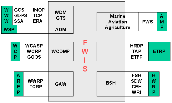
1.3 Considering the current state of the WMO Information System and the
overall vision of a future system Figure 1 highlights some of the key points:
- There is now limited utilisation of the Internet for operational store and forward
applications
- There is limited connectivity between applications developed to serve the needs of the
different Commissions
- There are a large number of different applications whose development has not been
coordinated making integration of data sets technically challenging
- Multidisciplinary application of meteorological, hydrological and oceanographic data is
hampered by lack of agreed standards needed to effectively identify, acquire and use all
of the relevant data
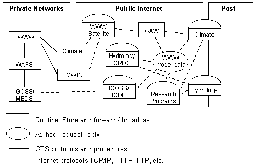
Figure 1. Current WMO Information Systems
1.4 The multiplicity of systems operated for different Programmes has
resulted in incompatibilities, inefficiencies, duplication of effort and higher overall
costs for Members. Continuing to develop systems in this uncoordinated manner will
exacerbate these problems and will further isolate the WMO Programmes from each other and
from the wider environmental community. It will increase the difficulty in sharing
information between programmes, which is essential for them to fulfil their requirements.
As a consequence, other organizations, environmental programmes or commercial concerns
might assume responsibility for providing essential data and services and WMO would thus
lose its leadership role.
1.5 One option to address these problems might be to enhance the GTS in
such a way as to generalize the services to all Programmes. However, the GTS would still
suffer from inherent deficiencies, some of which are listed below:
- Use of proprietary high level protocols that are not supported by the marketplace.
- Volume restrictions preclude the transmission of satellite imagery, as well as video and
other high volume data sets (in the order of gigabytes or terabytes).
- Lack of support for a request/reply system providing ad-hoc access to the data and
products available for international exchange.
- Inability to facilitate information insertion and distribution to programmes and public
and other clients beyond the meteorological community.
- Inability to rapidly (i.e. routinely near-real-time) identify where data losses are
occurring and undertake remedial action.
- Inability to easily accommodate requirements that include short periods of high volume
traffic followed by lengthy periods of low or no traffic.
- Inadequate product identification and metadata leading to duplication and uncertainty of
content.
1.6 Therefore, an alternative approach is proposed: a single
coordinated global infrastructure, the Future WMO Information System (FWIS). It is
envisioned that FWIS would be used for the collection and sharing of information for all
WMO and related international programmes. The relationship between functions performed by
FWIS and similar functions performed by current WMO Programmes is illustrated in Figure 2
below. The FWIS vision provides a common roadmap to guide the orderly evolution of these
systems into an integrated system that efficiently meets all of the international
environmental information requirements of Members.
Figure 2. FWIS relationship to WMO Programmes
1.7 FWIS should provide an integrated approach to meeting the
requirements of:
- Routine collection and automated dissemination of observed data and products
("push").
- Timely delivery of data and products (appropriate to requirements)
- Ad-hoc requests for data and products ("pull")
FWIS should be:
- Reliable
- Cost effective and affordable for developing as well as developed Members
- Technologically sustainable and appropriate to local expertise
- Modular and scalable
- Flexible and extensible - able to adjust to changing requirements and allow
dissemination of products from diverse data sources and allow participants to collaborate
at levels appropriate to their responsibilities and budgetary resources
FWIS should also support:
- Different user groups and access policies, such as WMO Resolutions 40/25
- Data as well as network security
- Integration of diverse datasets
1.8 Taking into account that information systems technology is evolving
rapidly, FWIS should utilize industry standards for protocols, hardware and software. Use
of these standards will reduce costs and allow exploitation of the ubiquitous Internet and
web services.
1.9 The ultimate implementation of FWIS would build upon the most
successful components of existing WMO information systems. It would
continue to rely
upon the WMO communication system (initially the GTS) to provide highly reliable delivery
of time-critical data and products. Currently, this requires a private network but this is
likely to change as public communications services evolve.
1.10 Executive Council has noted that a window of opportunity exists
now to arrive at an agreed standard for FWIS.
2. FUNCTIONS AND RESPONSIBILITIES
2.1 To clarify the concept of FWIS, three functional components are
defined: National Centres (NC), Data Collection or Product Centres (DCPC)
and Global Information System Centres (GISC). It should be noted that this is a
functional description defining responsibilities for data and product exchange. One
physical centre could perform the functions of one or more of these components. Likewise,
several physical centres could cooperate to perform the functions of a single functional
centre.
National Centres
2.2 FWIS NCs would serve data and product needs of their country. Most
NCs would be part of an NMHS. However, there might be others within the same country
having national responsibility for functions falling within WMO Programmes but located
outside of the NMHS. The participation of the centres would be coordinated through the
national Permanent Representative to WMO. NCs would:
- Collect observational data from within their country
- Provide observations and products intended for global dissemination to their responsible
GISC
- Provide observations and products intended for regional distribution to the responsible
DCPC
- Collect, generate and disseminate products for national use.
- Participate in monitoring the performance of the system.
Data Collection or Product Centres
2.3 Several dozen centres would serve as DCPCs. An existing RSMC would
fulfil the function of a DCPC but many additional centres would also serve as DCPCs. This
would include suppliers of special observations (e.g. ARGOS, ARINC, field experiments) and
centres producing products related to a specific discipline (e.g. ECMWF, NESDIS). As
appropriate, DCPCs would:
- Collect information intended for dissemination to NCs within its area of responsibility
(i.e. regional collections)
- Collect special programme-related data and products
- Produce regional or specialized data and products
- Provide information intended for global exchange to their responsible GISC
- Disseminate information not intended for global exchange
- Support access to their products via WMO request/reply ("Pull") mechanisms in
an appropriate manner
- Describe their products according to an agreed WMO standard and provide access to this
catalogue of products or provide this information to another centre with this
responsibility (e.g. a GISC)
- Ensure that they have procedures and arrangements in place to provide swift recovery or
backup of their essential services in the event of an outage (due to, for example, fire or
a natural disaster).
- Participate in monitoring the performance of the system.
Global Information System Centres
2.4 Several (perhaps 4 to 10) centres would serve as GISCs. Each GISC
would have a defined area of responsibility. GISCs would usually be located within or
closely associated with a centre running a global data assimilation system or having some
other global commitment, such as a WMC. However, the proposed architecture does not
dictate that this be a requirement. The responsibilities of a GISC can be summarised as
follows. Each GISC would:
- Receive observational data and products that are intended for global exchange from NCs
and DCPCs within their area of responsibility, reformat as necessary and aggregate into
products that cover their responsible area
- Exchange information intended for global dissemination with other GISCs
- Disseminate, within its area of responsibility, the entire set of data and products
agreed by WMO for routine global exchange (this dissemination can be via any combination
of the Internet, satellite, multicasting, etc. as appropriate to meet the needs of Members
that require its products)
- Hold the entire set of data and products agreed by WMO for routine global exchange and
make it available via WMO request/reply ("Pull") mechanisms
- Describe its products according to an agreed WMO standard and provide access to this
catalogue of products
- Provide around-the-clock connectivity to the public and private networks at a bandwidth
that is sufficient to meet its global and regional responsibilities.
- Ensure that they have procedures and arrangements in place to provide swift recovery or
backup of their essential services in the event of an outage (due to, for example, fire or
a natural disaster).
- Participate in monitoring the performance of the system, including monitoring the
collection and distribution of data and products intended for global exchange.
2.5 The flow of information between these centres is illustrated in
figures 3 through 5. Figure 3 outlines the collection of observations and products. It is
not considered necessary to standardise the physical links to be used between all of the
suppliers and collectors. These could instead be decided by bilateral agreement to best
match the requirements and capabilities of the parties involved. However, Members would be
encouraged to use standard protocols recommended by WMO.
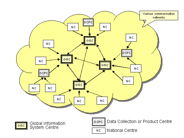
Figure 3. Information collection data flow
(Arrows indicate data flows; no physical links are implied)
2.6 Figure 4 illustrates the dissemination of products (both routine
and non-routine). Routine (i.e. scheduled) dissemination of observed data and products
would be accomplished through an automatic broadcast or "push" system that could
be implemented via a variety of technologies, including the existing GTS. Ad-hoc
(non-scheduled) and special requests for data and products would be satisfied by a
request/reply ("pull") system. The "push" and "pull"
systems, operating in parallel, should be available to all users of WMO data and products.
2.7 Figure 5 provides a simplified view of the various categories of
information flow.
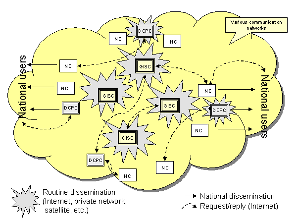
Figure 4. Information distribution
(Arrows indicate data flows; no physical links are implied)
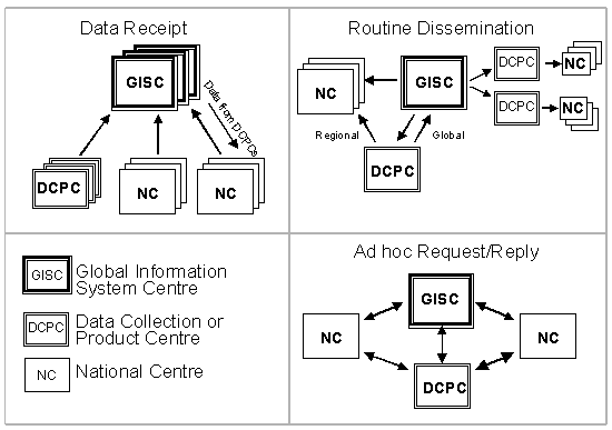
Figure 5. Overview of communication topologies
3. RELATIONSHIP TO EXISTING CENTRES
3.1 The information and communication responsibilities of existing WWW
and other WMO Programme centres can be mapped into the corresponding functions within FWIS
as illustrated in the table below. It should be noted that the FWIS functions will be
added to the existing functions and responsibilities of the participating centres, which
will continue.
Current WWW Centres |
FWIS Functions |
NMHS
|
NC |
RSMC
|
DCPC and/or GISC |
WMC
|
DCPC and/or GISC |
RTH
|
DCPC |
RTH on MTN
|
DCPC and/or GISC |
| Other Programme Centres |
NC and/or DCPC |
4. ENHANCED CAPABILITIES IN RESPONSE TO INCREASING RESPONSIBILITIES
4.1 NMHSs span a range of responsibilities and capabilities. FWIS
provides a flexible and extensible structure that would allow NMHSs to enhance their
capabilities as their national and international responsibilities grow. FWIS services of
less developed NMHSs with less demanding requirements could be successfully implemented
with Personal Computers and dial-up Internet connections, provided they receive basic
products via satellite broadcast (e.g. EMWIN, MDD, RETIM2000, etc.). As resources and
requirements increase, NMHSs could be equipped with increased capabilities as illustrated
in Figure 6. It should be noted that there is not a direct relation between the functional
FWIS components and the centres illustrated in the figure.
4.2 Increased capabilities at an affordable cost could be provided
using one or more PCs, a permanent connection to the Internet and, possibly, satellite
communications for assured and timely receipt of WMO products. Centres with these
facilities would have the capabilities to function as a NC or small DCPC.
4.3 Further capacity would be provided by PCs, workstations or servers,
a broadband Internet connection, and connection to the WMO communication system (GTS with
a dedicated message switch, UNIDART, and/or Internet Data Distribution (IDD)). A centre
with this infrastructure could serve as a fully functional NC or DCPC.
4.4 A full capacity centre would be equipped with a large computer
system (mainframe, multiple interconnected servers, workstations and PCs), a very
broadband Internet connection, and a high-speed connection (or multiple connections) to
the WMO communication system. A fully equipped centre with these capabilities could
provide the services of a sophisticated NC, DCPC, GISC or any combination of these three
centres.
5. TECHNICAL CONSIDERATIONS
5.1 For the near future, transmission of the current suite of global
products will continue to be distributed to WMO Centres via the existing GTS
infrastructure. However, implementation of request/reply systems and exchange of high
volume datasets (e.g. radar data, satellite imagery, and high resolution model output)
cannot be supported by the existing GTS. Realization of the FWIS vision requires that the
existing GTS dedicated communication links and message switches be augmented by additional
communications capabilities such as those provided by the commercial Internet and other
communication options.
5.2 The current GTS can be extremely costly to WMO Members and inhibit
participation in WMO data exchange due to high costs associated with dedicated lines,
acquisition of message switches, and ongoing costs of maintaining message switch routing
tables. Consequently, the Internet is likely to become the default communication carrier
for WMO FWIS data exchange and only where it does not meet the requirements of WMO
Programmes would use of private, dedicated circuits and message switches be justified.
However, the current capabilities of the Internet raise concerns for Members’
requirements for:
- reliable and continuous connectivity,
- sufficient bandwidth to handle peak-period data transmission,
- responsive delivery of time-critical information,
- a secure networking environment
These concerns must be addressed through long-term testing of Internet
capabilities and advanced methodologies (e.g. IPv6, QoS) that promise to provide a secure
network environment and predictable performance.
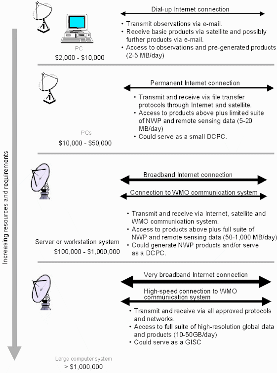
Figure 6. Capabilities of centres in response to
increasing requirements
The approximate value of computer hardware and software
performing FWIS functions is provided for each level in US dollars.
5.3 Use of alternative communications pathways and software to
facilitate data exchange can lower costs and simplify operational management of basic data
exchange between Members and can provide flexible and scalable solutions to meet changing
data exchange requirements. Alternative methodologies to communicate messages include the
Automatic File Distribution (AFD) system developed by the DWD and the IDD developed by the
UNIDATA Program Center. While these systems take different approaches to the transmission
of data products, they both have a proven history of operation and offer cost-effective
alternatives to message switches. Additionally, these methodologies can coexist on
dedicated or public communication pathways to provide maximum flexibility for data
exchange in a store and forward (push) environment.
5.4 In environments where dedicated communication lines are
prohibitively expensive or unreliable, receipt of basic data and pre-generated products
can be accomplished by relatively low cost satellite communication. However, the sending
of observations via two-way satellite transmission may be too expensive so use of dial-up
communications would be necessary.
5.5 To reduce costs for Members FWIS should:
Use cost-effective communication systems whenever practicable.
Cost-effective communication choices will vary between Regions and between Centres with
differing responsibilities and local communications infrastructure but compatibility
should be a paramount consideration.
Use commercial off the shelf or open source software where it is
available to meet requirements at reasonable cost.
Employ well-supported open-source software as the foundation for system
development when new software is required. System costs will be lowered and continued
development of systems will not rely on proprietary system components. Software code will
be readily available for modification to meet evolving needs.
Foster development of open-source projects. Parallel system development
is on-going at many Member organizations. Organized open-source projects, focussed on
common needs, will result in improved systems benefiting all Members.