1. Introduction
As part of Global Data Communication under the World Weather Watch programme
of WMO, India Meteorological Department is committed to provide Meteorological
data, analysed weather charts, weather warnings and satellite imageries
to ships and neighbouring countries within a radius of 6000 km around
New Delhi.
This document reflects towards improvement in broadcast of GTS data,
Weather charts, Output models and Satellite imageries using internet
and commercial satellite system as a cost effective means benefiting
end users in Central South Asia, Middle East and Far East countries.
India Meteorological Department has started a a new meteorological data
and processed products broadcasting service from 1st July 2003 using
World Space “Asia Star” satellite.
2.Broadcasting
Traditional broadcast through HF are being replaced worldwide by commercial
digital radio and data casting. In the same directions India Meteorological
Department has replaced HF broadcast services by utilizing commercial
data casting services from a company named “World Space”.
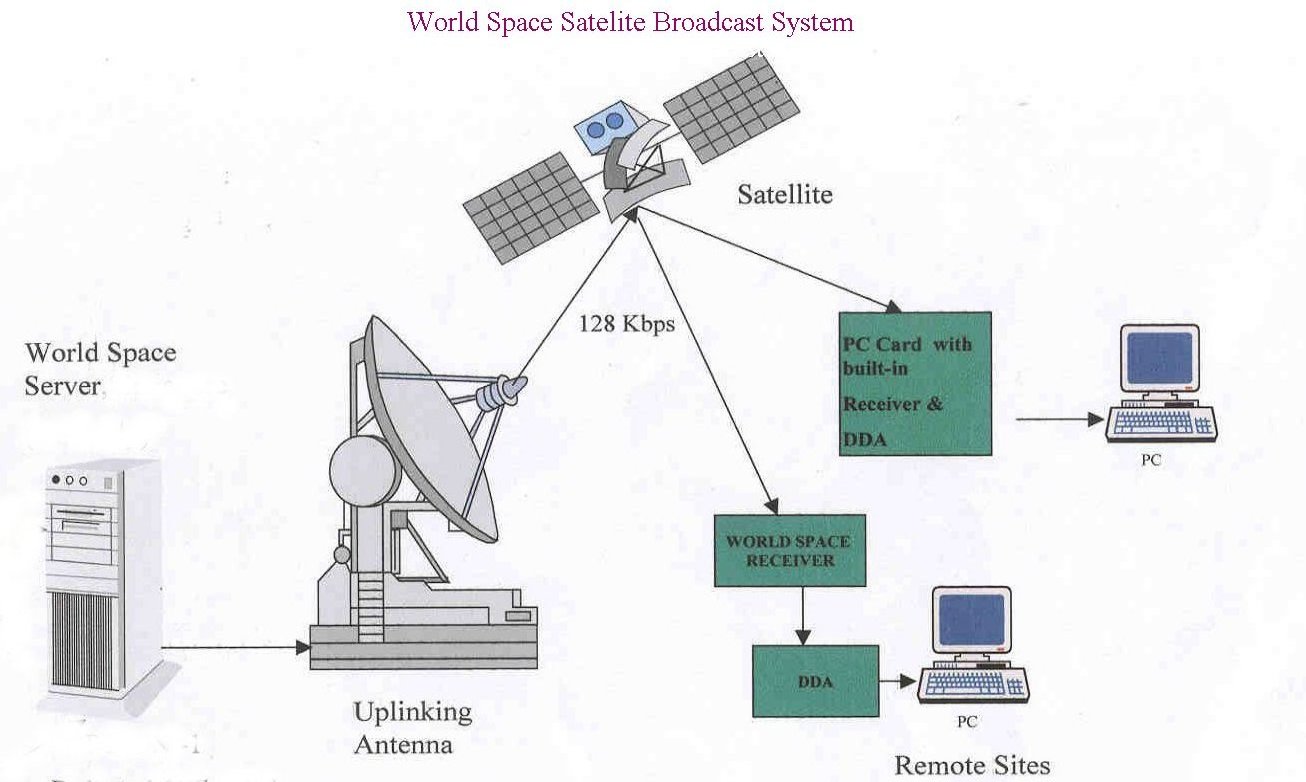
At RTH level (Analog and binary) files are automatically uploaded in
a server scheduled on hourly basis through FTP and graphics (analysed
weather charts, output models and satellite imageries) are loaded at
scheduled intervals through digital scanner or through IMD’s web
site. The products are uploaded to up linking facility at Singapore
through Internet. The up linking site broadcasts these products on hourly
basis through World Space satellite “Asia Star”.
3. Receiving system
The receiving system needs a very small L-band antenna, a commercially
available small and portable inexpensive digital satellite receiver
and a digital data adopter (DDA) at approximate cost of US$150 and a
Windows PC. The output of the receiver is fed to the DDA connected to
a Data acquisition and Visualization Work Station . The customized Software
can be used to visualize the data, satellite images, Weather charts,
Automatic plotting of data, analysis and manipulation of data for the
benefit of weather forecasters and other users. Printing of selective
satellite images and meteorological data and products is also possible.
The reception is in downlink frequency 1467 to 1492
MHz and down link speed of data is 128 kbps. For receiving the products
no human intervention is required. The data can also be received at
mobile platforms such as ships. The cost of uplinking is very nominal
appox. US 10$ per MB.With data compression, the broadcast is much more
cost effective. Most important aspect is that receiving system is not
affected by natural disasters and terrestrial disturbances, ensuring
that the signal reaches its destination in even the most adverse conditions.
The use of proprietary encryption ensures that only authorised recipients
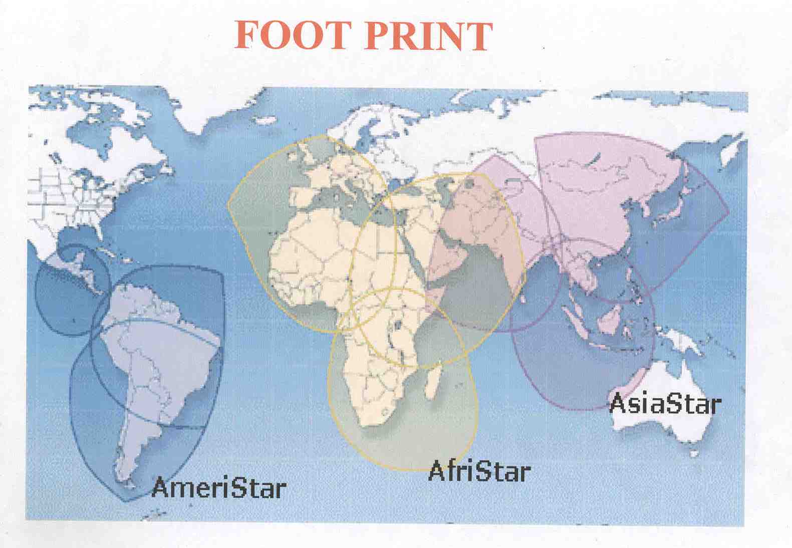
have access to such information. The beneficiaries are recipients covered
under the footprints of the World Space satellite Asia Star as given
in Fig. 1.
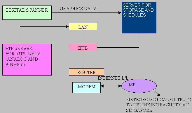
4. Setup at RTH New Delhi
The equipment setup at RTH New Delhi is as given in Fig.
2.Half hourly GTS files are generated at RTH computer and two consecutive
files are kept in a folder in a server (for digital broadcasting) automatically
through ftp process ten minutes before the full hour UTC .Within ten
minutes slot these files are uploaded through scheduler on the up linking
server at Singapore through Internet link. The graphics ( processed
weather charts, output models and satellite imageries) are either scanned
through digital scanner or directly from IMD’s web site are kept
on the server at RTH and through scheduler are uploaded to up linking
server through Internet link. The products are broadcast at full hour
UTC. Broadcast arrangement is shown in Fig.3 System
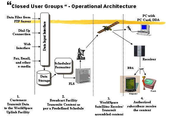
Operational Architecture is shown in Fig.4.
5. Meteorological products
(i) GTS data (SYNOP, PILOT, TEMP, METAR, TAF , Weather warnings etc.)
of India and neighbouring countries.
(ii) Satellite images of INSAT and KALPNA are now being broadcast for
wider coverage which, earlier was not possible due to limitation of
the footprint of these satellites.
Indian Satellite Images such as three hourly Visible, Infrared, Colour
and Water Vapour images.
(iii) Analysed Weather charts and model outputs.
6. Service plan
In the initial phase data receiving sets have been installed at national
centers and the reception is satisfactory.
In the second phase the service will be extended by increasing facilities
at more national centers as well as to neighbouring countries.
Note: Digital data casting through internet and satellite
broadcast is cost effective and reliable, noise free communication solution
as a replacement to obsolete HF broadcast service. Implementation of
the satellites “Amri Star”
And “Afri Star” will give world wide coverage.
|