|
|
|
Annual WWW Technical Progress Report on the Global Data-Processing System - 2000 Country: Brazil Centre: Brasilia - INMET - National Meteorological Institute
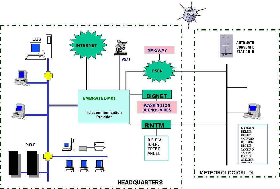
1 Summary of highlights Several steps were taken during the recent past years. One of the most important was the implementation, in 1995, of the RNTM (National Meteorological Telecommunication Network) which congregates the four major operational Meteorological Centres in Brazil (INMET, DHN, DEPV, ANEEL), and the Research Centre CPTEC. With this connection, a National Meteorological Data Bank created and installed at INMET, in Brasilia, to store the national surface and upper-air data. The network also includes the 10 Regional Districts of INMET located in the country which are responsible for the national data collection. Another major achievement happened with the operationalization of Regional Modelling Systems at the Navy (DHN) in 1996 and at INMET in 1999, to support several programs in the country.
2 Equipment in use
In INMET, the total capacity for storage on disk is around about 1 Tbytes. There are around 300 personal computers based on Intel microprocessor, 40 RISC workstations and several other supporting devices. The operational system used on the main machines is UNIX and the major software for handling the data base is ORACLE.
3 Data and products from GTS in use All alphanumerical and binary data at global level are received at INMET. The Centre is directly connected to the WMC Washington at a high speed link. The GRIB/GRIDS from NWS and ECMWF are used in operational basis. The RTH Brasilia receives about 19,000 bulletins daily and transmits around 100,000 bulletins (data and products).
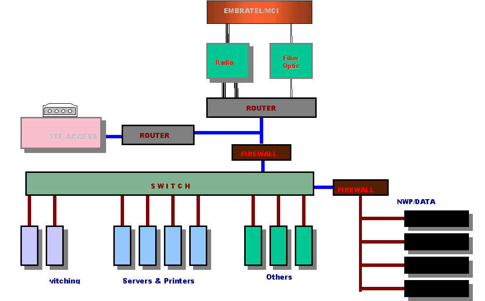
4 Data input system Fully automated system. The routine to convert incoming reports in character oriented code forms into BUFR is being implemented. Besides that, the initialisation data for the model run are currently obtained from Germany´s DWD via FTP using Internet. The access port to the internet at INMET, is set at 384 Kbps.
5 Quality Control System There is no quality control system in use regarding outgoing data to the GTS, but the format is checked before transmission. The bulletins are received from the National Collecting Centres and are automatically recompiled to be transmitted. The format of all received bulletins are checked for syntax coherence and corrected if possible.
6 Monitoring of the Observation System Surface and upper-air observation are quantitatively monitored on national level. Currently we are operating a network comprising around 350 surface stations and 26 upper-air stations.
7 Forecast System 7.1 System Run Schedule A) Continental Forecast The National Meteorological Service has implemented during the year 1999 the High Resolution Model (HRM), which was developed by the DWD, Germany. The model was then termed MBAR - Modelo Brasileiro de Alta Resulução (High Resolution Brazilian Model). The HRM is integrated twice a day, 0000 UTC and 1200 UTC, for a forecasting period of 48 hours. It is being initialised with the analysis from the Germany Global model. At INMET, Brasilia, HRM is run operationally for short-range forecast (48 hours). For medium range forecast, model output from other centres is accessed. B) Marine Forecast Forecast is made twice a day, at 00:00 UTC and 12:00 UTC, for periods up to 48 hours, for an area comprising the METAREA V and Drake Strait and Antarctic Peninsula region.
7.2 Medium-range Forecast System Continental Forecast The forecasters at INMET use the medium-range model output from the MRF (Medium-Range Forecast) model run by the American NCEP (National Centers for Environmental Prediction). The only field used is the deterministic rain forecast, from 24 through 132 hours, over South America. B) Marine Forecast Not applicable
7.3 Short-range Forecast System 7.3.1 - Data assimilation, objective analysis and model initialisation A) Continental Forecast The MBAR model is initialised from the analyses of the GME, the Global Model run by DWD. These analysis are transmitted twice a day (0000 UTC and 1200 UTC), by FTP, from DWD to INMET. Before the analyses are incorporated into the HRM, they are interpolated from the GME grid to the HRM grid, and subject to a nonlinear normal mode initialization procedure. B) Marine Forecast Same as for continental, except that the procedures are run at DHN.
7.3.2 - Model A) Continental Forecast INMET runs locally a version of the HRM model developed by DWD, termed MBAR. It is a limited area, finite difference, hydrostatic, primitive equation model whose domain covers most of South America. A horizontal grid spacing of 25 km is used. B) Marine Forecast Model HRM (High Resolution Model), developed by DWD.
7.3.3 - Numerical Weather Prediction Products A) Continental Forecast The operational forecast of INMET have access to a visualisation software that displays several surface and upper air fields, such as mean sea level pressure, accumulated precipitation, temperature, geopotential height, relative humidity, cloud analysis, winds, vorticity divergence and others fields. The community as a whole has access to the MBAR output through the web pages. Forecast fields of geopotential, winds, temperature, accumulated rain and cloud cover are available in INMET's home page, http://www.inmet.gov.br. B) Marine Forecast Fields of various meteorological parameters, visualised using GRADS software; and meteograms of specific points. 7.3.4 - Operational techniques for Application of the NWP products A) Continental Forecast None yet, but it has been considered for the short term future. B) Marine Forecast Not applicable.
7.4 Special Prognostics for Marine Coast, Ice, Tropical Cyclones, Dispersion and Transportation of Polluted materials and Solar Ultra-Violet Radiation (UV) 7.4.1 Assimilation, objective analysis and data initialisation (if proceed) A) Continental Forecast Not applicable b) Marine Forecast Oceanic Model forced by 10m winds produced by HRM model, initialised with parameterisation of height field and waves periods by function of wind intensity.
7.4.2 Model A) Continental Forecast Not applicable B) Marine Forecast WAM Model, developed by Max-Planck Institute, Germany, reaching METAREA V, producing 48 hours forecast periods.
7.4.3 Products of numerical prediction A) Continental Forecast Not applicable B) Marine Forecast The wave model provide sea parameters such as height fields, directions and periods of the waves. We also perform measurements at specific points by using appropriated equipment.
7.4.4 Operational techniques of the products A) Continental Forecast Not applicable B) Marine Forecast Not applicable
7.5 Extended-Range Forecast (10-30 days) A) Continental Forecast Not applicable B) Marine Forecast Not applicable
7.6 Extended-Range Forecast (30 days – 2 years) INMET is implementing a system of statistical seasonal forecast.
8 Verification of Prognostic Products INMET has not yet a verification system other than subjective analysis of some variables, such as accumulated precipitation over a 6 hours period, surface wind field, MSL pressure field, relative humidity and temperature. Objective analysis using bias, R.M.S and other statistics has been planned and it will be implemented soon.
9 Plans for the Future INMET is acquiring two CRAY computers: 1 Cray-SGI Origin 2000 about to with 32 processors and one Cray SV-1 with 8 processors to take care of the Numerical Weather Prediction activities. The process to install 200 automatic station in the national network has started and the observations will be available soon. Regarding NWP, future plans include:
10 References DWD, 1999, Quarterly Report of the Operational NWP-Models of the Deutscher Wetterdienst, 20, 63 pp. Documentation of the EM/DM – System – Deutscher Wetterdienst – Research Department, 1995. HRM – User’s Guide – Majewski, D., 1999. Wamodel Cycle 4 (Revised Version) – Deutscher KlimaRechenZentrum – Gunther, H., Hasselmann, S., Jansenn, P. A. E. M., 1992.
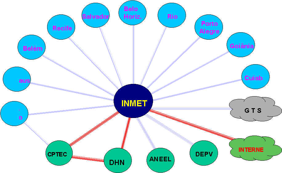
11 List of acronyms ANEEL - National Electric Energy Agency CPTEC - Centre for Weather Forecasts and Climate Studies DEPV - Electronic and Flight Protection Directory DHN - Hydrography and Navigation Directory DWD - Deutscher Wetterdienst ECMWF - European Centre for Medium Range Weather Forecast Centre GTS - Global Telecommunication System INMET - National Meteorological Institute NWP - Numerical Weather Product NWS - National Weather Service WMC - World Meteorological Centre 12 DIAGRAMS National Backbone
Logical Diagram
Operational Diagram
|