PROGRESS REPORT ON THE GLOBAL DATA PROCESSING SYSTEM
BRAZIL (1995-2000)
CENTRO DE PREVISÃO DE TEMPO E ESTUDOS CLIMÁTICOS (CPTEC) INSTITUTO NACIONAL DE PESQUISAS ESPACIAIS (INPE)
1. Introduction
The Center for Weather Forecasts and Climate Studies (Centro de Previsão de Tempo e Estudos Climáticos, CPTEC) was planned and designed in late 80s and implemented in early 90s by the National Institute for Space Research (Instituto Nacional de Pesquisas Espaciais, INPE). It is the fruit of the dedication of a highly motivated group of research scientists, engineers and meteorologists assigned to implement CPTEC who have mastered the science of meteorology, the physico-dynamical models of numerical weather prediction (NWP) and the computer science during the past two decades. CPTEC started producing operational global numerical weather forecasts using a spectral atmospheric general circulation model (CPTEC/COLA model) with a resolution of T62L28 in January 1995. CPTEC is the first and the foremost operational center in Latin America to have both NWP and seasonal numerical forecasting capabilities.
The NWP and numerical climate prediction (NCP) operational products of CPTEC are disseminated to thousands of users and to the general public in and around Brazil through the media and the Internet. CPTEC's mission is to constantly improve the reliability and quality of its operational products, especially its weather and climate forecasts, by keeping abreast with technological developments, both in the atmospheric and oceanic sciences and in the high performance computing and information sciences.
CPTEC has always striven to excel both in operational meteorology and atmospheric science research. Today CPTEC has more than 40 Doctorates and 25 Masters conducting research in many frontiers of environmental sciences. A well established and traditional postgraduate course leading to Master’s and Doctor’s degrees in meteorology at INPE provides qualified manpower for CPTEC as well as to many upcoming meteorological organizations in Brazil and neighboring countries.
2. Highlights
2.1 Operational Forecast models
(i) Jan 1995 - CPTEC/COLA Global Spectral Model (developed originally at the Center for Ocean Land Atmosphere Studies – COLA) with T62L28 resolution (Bonatti, 1996) runs once a day for 6 days forecast with 00 UTC NCEP 2.5 degree analysis. Model Physics contains: Silhouette orography, simple biosphere model (Sellers et al. 1986), planetary boundary layer (Mellor and Yamada 1982), shallow convection (Tiedke 1983), deep convection (Kuo 1965), shortwave radiation (Lacis and Hansen 1974), longwave radiation (Harshvardhan and Corsetti 1984), cloud-radiation interaction (Slingo 1987).
(ii) July 1995 – The global models runs twice daily with 00 UTC and 12 UTC analyses from the NCEP
(iii) December 1996 - Regional Eta model (Black 1994) (developed at Belgrade University, improved at NCEP and adapted to South American conditions at CPTEC) runs twice a day with the initial and boundary conditions obtained from the global run for 00 and 12 UTC. Vertical coordinate uses step orography (eta). Boundary conditions are updated every 6 hours. Resolution: 40 km in the horizontal and 38 levels in the vertical. Model Physics contains: Shortwave radiation (Lacis and Hansen 19974), longwave radiation (Fels and Schwartzkoff 1975), convection (Betts and Miller 1986, Janjic 1994), boundary layer (Mellor and Yamada 1974), cloud forecast scheme (Zhao et al. 1994), bucket scheme for soil moisture (Manabe 1969).
(iv) January 1996 - CPTEC/COLA model is used experimentally once a month to run seasonal (4 months) forecasts with 4-member ensemble. Lower boundary conditions (SST observed anomalies) are obtained from NCEP analysis.
(v) January 1998 - CPTEC/COLA model is used for experimental global NWP runs with CPTEC/JMA OI analysis. These runs are used as standby runs.
(vi) November 1998 - Climate prediction is produced once a month with 9-members ensemble, with SST anomalies forecast by NCEP model.
(vii) January 1999 - Global NWP model is parallelized
(vii) November 1999 - Global NWP model is upgraded to T126L28 resolution.
(viii) November 1999 - Climate model runs with 25-member ensembles with SST anomalies (boundary conditions) persisted and forecast by the NCEP coupled model.
(ix) Research models: The FSU global spectral and regional models and RAMS
2.2 Observations, quality control and assimilation
2.2.1 Data sets
(a) The GTS data is obtained regularly from the INMET (Instituto Nacional de Meteorologia) at Brasília. This set contains SYNOP, SHIP, BUOY, TEMP, AIREP, PILOT, SATOB, SATEM and TOVS messages from all over the globe with some gaps. The coded data is preprocessed and fed to the CPTEC’s Meteorological Data Bank (MDB) and to the analysis (OI) module.
(i) Approximate statistics of the SYNOP and TEMP messages from Brazil, after suppressing the erroneous data messages, are given below.
220 SYNOP stations, maily reporting at 00, 12 and 18 UTC hours. On the average 85 messages per month per station are obtained.
22 TEMP stations mainly reporting at 12 UTC. On the average 21 messages per month per station at 12 UTC are received.
06 TEMP stations report at 00 UTC also, with the same average number of messages per month as above.
(ii) Approximate statistics of data received for the globe after subtracting the erroneous data are given below.
SYNOP+SHIP = 15600 messages per day
TEMP = 1100 messages per day
(These statistics are based on February 2000 data)
(b) GOES-8 satellite imagery: 3-hourly full disk and hourly extended north and south images for the SA region in full resolution and for the 5 channels
NOAA 12, 14 and 15 imagery: All the three passages over the Brazilian region are daily recorded by stations at Cachoeira Paulista and Cuiabá, for ascending and descending orbits (recorded files: 5 channel AVHRR and TOVS data)
Meteosat imagery: 6-hour global disk in visible, water vapor and infrared channels, full resolution
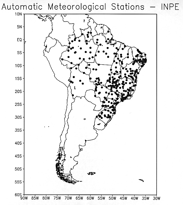
(c) Three-hourly data from the automatic surface stations deployed by INPE and ANEEL at approximately 300 sites in Brazil is received with the help of the Brazilian satellite SCD-1 and SCD-2 during their passages over Brazil. These data are mainly precipitation, wind, humidity, temperature and solar radiation. (Array of the automatic stations over Brazil and neighborhood deployed by DAEE and INPE is given in Fig. 1. They include approximately 100 meteorological stations and 200 hydrological stations.)
(d) METAR data from the Brazilian airports are received regularly, approximately 200 messages per hour from all over South America.
(e) The global analyses at T126 resolution (spectral coefficients) updated twice daily, SST analyses (weekly running means), ice files, snow cover files updated once a day are obtained from the NCEP.
(f) Raingauge data from many states of Brazil are received once a day. The data are transmitted by telephone to State Meteorological Offices supported by the Ministry of Science and Technology (MCT) and are retransmitted to CPTEC. There is a delay of 24 to 48 hours before all the data are received by CPTEC. The number of stations in the Northeast Brazil are roughly 1100. The states of Santa Catarina and Paraná in southern Brasil also provide nearly 40 rainfall and temperature data with a lag of just few hours.
(g) Radar imagery from five radar stations (four from the state of São Paulo and one from the state Paraná) located at São José dos Campos (45o.87’W, 23o.12’S), Salesópolis (23o.36’S, 45o.58’W), Baurú (22o.21’S, 49o.01’W), Presidente Prudente (22o.07’S, 51o.23’W) and Curitiba (49 o.17’W, 25o.33’S) are received every 15 minutes.
2.2.2 Quality control
Syntax, coding and transmission error checks of the messages are performed in the preprocessing module where the messages receive reliability flags and converted into BUFR format, and transfered to MDB and the Analysis modules
Generation of data coverage maps (Windobs) every 6 hours with 6-hourly windows
Radiosonde (TEMP) data receives hydrostatic check in the Analysis module
Graphs and tables of the quantity of data received and utilized daily for every calendar month by type (SYNOP, TEMP, AIREP, TOVS, etc.) are prepared.
2.2.3 Analysis
OI is performed operationally (used in global model standby runs) at 00, 06, 12 and 18 UTC. First guess is obtained from the NWP run of the previous synoptic hour.
Global analyses of NCEP for 00 and 12 UTC are received in two resolutions: T62, T126 at around 08 and 20 UTC respectively.
2.2.4 Meteorological Data bank (MDB)
The Meteorological Data Bank presently stores observations output by the pre-processing system in BUFR format. It is built on the top the software for database management ORACLE, and it was adopted at CPTEC from the NEONS system of Meteofrance. Data can be retrieved from the MDB using the visualization software METVIEW, or through a set of utility programs.
3. Equipment in use at the center (Fig. 2)
3.1 Supercomputers
NEC SX4/8A (8 processors) 16 GFLOPS velocity - Jul 1998
16 GFLOPS of peak velocity
8 GBytes of main memory
147 GBytes Disk capacity
Operational system: Super UX (UNIX)
Compilers: Fortran 90, C and C++
Network interface: FDDI, Fast Ethernet
(ii) NEC SX3/12R (1 processor) - Aug 1994
3.2 GFLOPS of peak velocity
512 MBytes of main memory and 1 GBytes of extended memory
83 GBytes Disk capacity
Operational system: Super UX (UNIX)
Compilers: Fortran 77, C and C++
Network interface: FDDI, Ethernet
3.2 Archiving subsystem
(i) DEC Alpha 3000/500 Server with
128 MBytes of Memory
Disk capacity of 150 GBytes
Optical Disk Library of 96 GBytes
Performance: SPECmark de 126.1
Operational system: UNIX
Compilers: Fortran 90, C and C++
Network interface: FDDI, Ethernet
(ii) 2 Servers DEC Alpha 4100 5/300 with
512 MBytes of Memory
Disk capacity of 300 GBytes
Tape Library of 10 TBytes
Performance: SPECint95 of 8.11 and SPECfp95 of 12.7
Operational system: UNIX
Compilers: Fortran 90, C and C++
Network interface: FDDI, Ethernet
3.3 Telecommunications Subsystem
2 Servers DEC Alpha 3000/500 with
128 MBytes of Memory
Disk capacity of 16 GBytes
4 Tape Drives 8 mm
Optical Disk Library of 10 TBytes
Performance: SPECmark of 126.1
Operational system: UNIX
Compilers: Fortran 90, C and C++
Network interface: FDDI, Ethernet
3.4 Network
Optical Fiber Local Area Network in a FDDI ring with 100 Mb/s interlinking the Supercomputers and the Servers.
Seven (7) subnetworks with a speed of 10 Mb/s
3.5 External links
X.25-Renpac for external user connections and STM400
CPTEC with INPE S. J. Campos at 1 Mb/s
INPE Cuiabá at 512 Kb/s
FAPESP (São Paulo) at 128 Kb/s
INMET (Brasília) at 256 Kb/s
DHN (Niteroi) at 64 Kb/s
SRH (Salvador) at 64 Kb/s
São Luiz at 9600 bps
Belém at 9600 bps
CPTEC is one of the nodes of the Brazilian Meteorological Telecommunication Network (RTM)
3.6 Network Servers
07 DEC Alpha 3000/4000 with 96 MBytes of Memory and 16 GBytes of Disk
storage
01 Tape unit DAT
01 Server DEC Alpha 3000/700
01 Server Alpha Station 600
3.7 WEB System
01 Compaq Alpha Server DS20 with 512 MBytes of Memory and 37 GBytes of
Disk storage
Operational System: UNIX
Web server: Apache 1.3
3.8 Workstations
44 DEC Alpha 3000/300 with 64 MBytes of Memory and 1 GBytes of Disk
storage
05 DEC Alpha Stations 200 4/100 with 64 MBytes of Memory and 1 GBytes of Disk
02 DEC Alpha Stations 200 4/166 with 64 MBytes of Memory and 1 GBytes of Disk
04 DEC Alpha Station 255/300 with 128 MBytes of Memory and 4.3 GBytes of Disk
01 Compaq Alpha Station XP1000 with 1 GBytes of Memory and 120 GBytes of Disk
01 Compaq Alpha Station XP1000 with 256 MBytes of Memory and 5 GBytes of Disk
03 Compaq Alpha Station XP1000 with 512 MBytes of Memory and 5 GBytes of Disk
01 Alpha Server DS20 500MHz – 2 CPUs, 1GByte memory, 230 Gbyte disk
01 Alpha Server DS20 500MHz – 1 CPU, 1GByte memory, 125 Gbyte disk
3.9 Microcomputers
32 Intel Pentium with Windows 95/98/NT and Linux
11 Intel 486 with Windows 3.11 and Office PRO
4. Visualization software
4.1 GRADS GS Scripts (developed at CPTEC/INPE): This has animation, navigation, zoom, superposition, multiple window viewing capabilities. The fields can be displayed either in isolines or color or gray scale shading. It can mix the satellite imagery with the meteorological fields. Wind fields can be displayed either in vector mode, meteorological mode (wind barbs) or streamlines and isotachs mode. The isotach analysis on the streamlines can be displayed either in color code or as isolines or shaded modes.
4.2 METVIEW V1.7 (developed jointly by ECMWF and INPE): It has all the capabilities of GRADS. In addition this can handle the station data and surface chart plotting and analysis. METVIEW is connected to the Meteorological Data Bank (MDB) developed at CPTEC, and can access data from remote machines.
4.3 VIS5D: This has the capability of three-dimensional display of meteorological fields including their rotation on x, y or z axis. The 3-D fields can be chopped to view any section (meridional, longitudinal, vertical or any oblique section). This is specially suited for volume depiction and for viewing isosurfaces and 3D trajectories of air parcels. This can be coupled to Tcl/Tk in order to make scripts to facilitate its use.
4.4 SPRING: This is a geographic information system with political boundaries, cities, vegetation types, highways and roads, rivers and water bodies and industry types. It imports the NOAA imagery (hot spots), rainfall data, and forest fire risk index maps, and facilitates the user to identify the precise location of the hot spots and their forecast for the municipalities. This has the capability of zoom-in, zoom-out, navigation, statistics calculation and other facilities.
5. Forecast System
Global atmospheric prediction model
Regional atmospheric prediction model
Global wave prediction model
Simple Hydrological model at 0.25 degrees lat lon resolution over Brazil
Both global and regional NWP models run twice daily with 00 and 12 UTC analyses. Global model provides the boundary condition updates every 6 hours for the regional model. The 00 UTC (12 UTC) low resolution (T62) global model run and its post processing are ready at or around 10 UTC (22UTC), the regional model (40 km resolution) around 12 UTC (24 UTC) and the high resolution global model (T126) around 13 (01 UTC). These main forecast runs of the global models integrate up to 7 days. The intermediate runs at 06 and 18 UTC are integrated up to 12 hours. The regional model runs integrate up to 60 hours. The wave model obtains the boundary conditions from the global atmospheric model runs. The hydrological model takes into consideration orography, topology (drainage network), soil types, vegetation index, receives observational precipitation and evaporation data as input, and works out soil moisture and runoff forecasts.
6. Medium range forecast system (1 to 7 days)
Analysis : spectral coefficients for vorticity, divergence, geopotential, humidity and wind components supplied by NCEP
Domain : Global
Horizontal and vertical grid: T126L28 (Sigma=1.0, etc.) and T62L28
Assimilation cycle: 6 hourly
Basic equations: Hydrostatic primitive equations
Independent variables: x, y, Sigma, t
Dependent variables: u, v, Theta, q, wc, surface pressure, geopotential
Integration scheme: Semi-implicit time integration scheme
Horizontal diffusion:
Orography
Land-sea mask
Physics parameterization:
Surface and soil
Boundary layer
Cloud/precipitation
Radiation
Convection
Gravity-wave drag
m. NWP products:
Meteograms for more than 300 stations (grid points) in Brazil and the globe (see Fig. 3 for an example)
Forecast fields of meteorological variables and derived quantities (Temperature, Wind, Geopotential, etc. at the mandatory levels and surface pressure, precipitable water, outgoing longwave radiation, etc. for the relevant levels) for 6, 12, 24, 30, 36, 42, 48, 54, 60, 72, 84, 96, 120, 144, 168 hours
Trajectory forecasts
7. Shortrange forecast system (0 – 60 hours)
Analysis : spectral coefficients for vorticity, divergence, geopotential, humidity and wind components supplied by NCEP
Domain : Regional (90W-25W, 55S-12N)
Horizontal and vertical grid: 40 km, Arakawa E, 38 levels
Assimilation cycle: not applicable
Basic equations: Hydrostatic primitive equations
Independent variables: x, y, Eta, t
Dependent variables: u, v, T, q, wc, surface pressure, TKE
Integration scheme: Split Explicit, forward-backward
Horizontal diffusion: Nonlinear 2nd order
Orography: Silhouette, step mountain
Land-sea mask
Physics parameterization:
Surface and soil
Boundary layer
Cloud/precipitation
Radiation
Convection
m. NWP products:
Meteograms for more than 80 stations (grid points) in Brazil and South America
Forecast fields of meteorological variables and derived quantities for 6, 12, 18, 24, 30, 36, 42, 48, 54 and 60 hours
Trajectory forecasts
8. Long-range or seasonal forecast products (1 – 6 months)
Global precipitation anomaly for four three-month periods. (Ex. if the forecasts are issued in January, the three month periods are Jan-Feb-Mar, Feb-Mar-Apr, Mar-Apr-May and Apr-May-June.)
Global precipitation monthly anomaly forecasts for 6 months. Areas with little statistical significance are masked out.
Global mean seasonal surface temperature anomaly for four three-month periods. (Ex. if the forecasts are issued in January, the three month periods are Jan-Feb-Mar, Feb-Mar-Apr, Mar-Apr-May and Apr-May-June.)
Global mean monthly surface temperature anomaly forecasts for 6 months. Areas with little statistical significance are masked out.
Precipitation anomaly evolution forecast for six months for specific critical areas in Brazil (Ex. Northeast Brazil), all members of the ensemble and the ensemble mean.
Same as (e) but for several river basins in Brazil.
9. User products
They are of three types: graphical, tabular or textual. Usually a product for an end user is a combination of all the three types. (Ex. A sectorized satellite IR image + Table of weather condition icons for three days + text explaining the predicted significant weather for a region or for selected locations)
Catchment area forecasts (graphical)
Highway meteorological conditions (graphical) forecasts
Agricultural cooperative bulletins (graphical + textual)
Utilities bulletins (graphical, tabular and text)
Civil defense bulletins (severe condition alerts and warnings)
Bulletins for decision makers
10. Internet products (www.cptec.inpe.br)
10.1 Meteorological products
These are essentially four types: binary fields, charts and graphs in gif format, satellite pictures and textual bulletins.
(a) Satellite pictures derived from NOAA, GOES and METEOSAT satellites. The pictures are of many sizes: subregional, regional, full Disks and GOES+METEOSAT joint pictures covering the region between central Pacific and western Indian Ocean.
Nocturnal fog detection in satellite imagery (hourly pictures for southeastern Brazil)
Wind fields in high, middle and low troposphere over SA assessed from GOES imagery (in the process of installation)
Convective complexes tracking using GOES satellite imagery over SA (in the process of installation)
TOVS products over SA (temperature at 1000 and 500 hPa, geopotential at 500 hPa, precipitable water, lifted index, OLR) and temperature and dew point profiles
(b) Gridded data (GRIB format) and GIF format forecast maps of rainfall, temperature, winds, humidity at the surface and upper levels and many derived fields such as vorticity and divergence, mostly over the South American region. GIF format maps for the whole globe are also available for Mean Sea Level Pressure, 925 hPa Relative Humidity, 1000 hPa Temperature, 500 hPa – 1000 hPa Thickness, 24- hr accumulated Precipitation.
(c) Meteograms for 315 locations (Brazilian, South American and Global stations) from global model and for 89 locations (Brazil and South America region) from Regional model.
(d) Daily weather bulletins and forecasts (text) for all the regions in Brazil
(e) Model evaluation statistics: (i) Regional model: Monthly mean values of Mean error (Bias) for Pmsl, T850, U850, u and v at 10 m level, Ts, and root mean square error and standard deviation of Pmsl, T850 and U850, (ii) Global Model: Monthly mean values of Mean error (Bias) for Pmsl, T850 and U850, and root mean square error and standard deviation of Pmsl, T850 and U850.
(f) Climate products
Accumulated rainfall in the last 5, 10 and 30 days
Monthly rainfall and anomalies
Monthly mean temperature and anomalies
Observed SST anomalies in the Equatorial Pacific and Atlantic
Infoclima
Longrange seasonal rainfall and temperature anomaly forecasts (access with password)
Forest fire risk maps for Brazil
Observed forest fire density maps for South America
(g) Climanálise: Journal reporting the monthly weather and climate information over Brazil and neighborhood and scientific articles.
10.2 Environmental products
(a) Fire pixel density charts derived from the NOAA (polar orbiting) satellites updated every 8 hours for South America (SA)
(b) GOES-8 derived fire pixel density graphs (experimental product) for SA
(c) Forest fire risk charts, observed and forecast for SA, updated once a day
(d) Vegetation index (NDVI) over SA obtained monthly from NOAA-AVHRR imagery (resolution: 4-6 km)
(e) Solar radiation fields (weekly and monthly means) assesses from GOES-8 visible channel (Northeast, South-South-Eastern brazil and South America are being installed.)
(f) Sea-surface temperature over Atlantic Ocean near Brazil, assessed from GOES-8 imagery (daily, weekly and monthly fields)
(g) Observed soil water storage charts for Northeast Brazil, derived from observed rainfall data, daily, weekly, fortnightly and monthly (experimental product).
11. Verification of prognostic products
11.1 Global runs
(a) The performance statistics used to evaluate the global model are obtained for four sectors of the globe: Northern Hemisphere (NH, 20N-80N), Southern Hemisphere (SH, 80S-20S), South America (SA, 60S-15N; 100-10W) and Tropical Belt (TB, 20S-20N) for 24, 48, 72, 96, 120, 144 hour forecasts. Anomaly Correlation (or Skill), Mean Error (BIAS) and Root-Mean-Square Error (RMSE) are calculated for geopotential and zonal and meridional wind components at 850, 500 and 250 hPa, for virtual temperature at 1000, 850, 500 and 250 hPa, specific humidity at 925 hPa, surface pressure and precipitable water, for 24, 48, 72, 96, 120, 144 hour forecasts of the 00 and 12 UTC runs.
NH: Skill of geopotential, virtual temperature, mean sea level pressure, precipitable water and specific humidity.
SH: Skill of geopotential, virtual temperature, mean sea level pressure, precipitable water and specific humidity.
TB: zonal and meridional wind components at 850, 500 and 250 hPa levels.
SA: all statistics at all the levels mentioned above.
Fig. 4 shows the yearly mean anomaly correlations of 500 hPa geopotential seasonwise and for NH, SH and SA.
(b) Subjective evaluation of the positions and trajectories of the pressure centers and frontal systems in the South American region for 00 UTC run.
11.2 Regional runs
(i) Equitable threat score for the precipitation forecast for 00 and 12 UTC runs
(ii) Standard deviation
(iii) Monthly mean error (Bias) and RMSE of the prognostics for Pmsl, temperature and humidity at 850 hPa for 00 and 12 UTC runs separately
11.3 Visual comparison of forecasts and observations
(i) Daily precipitation forecast charts for forecast ranges up to 60 hours of both models and the observation chart
(ii) Same as (i) except for monthly accumulated precipitation.
12. Validation of CPTEC/INPE model
The use of CPTEC/COLA global atmospheric general circulation model for seasonal prediction is validated by processing a 10-year long run and evaluating the results. The model successfully reproduced the seasonal cycles, the regional climatologies and the interannual climate variability due to low frequency phenomena such as El Niño and La Niña. These results are being reported to the scientific community in the Congresses, Symposia and Workshops and also through specialized scientific journals.
13. Plans for the future
13.1 Computer system (Fig. 5)
(a) NEC SX5-28 with 100 Gflops of effective performance
128 GBytes of Memory
1 TByte of Disk capacity
(b) For Meteorological Data Bank (MDB)
Cluster of Servers Compaq Alpha with 1.5 Tbytes of RAID Disk
Robot unit for cartridge storage of 20 TBytes
(c) Upgrade of LAN to Fast Ethernet, distribution and hubs
New Systems for Firewall, Web server front-end, comprising mainly of Compaq
Alpha and Cisco machines.
13.2 Data analysis
(a) Meteorological data bank to include gridded (forecast and analysed) variables
(b) Assimilation of satellite derived winds and temperatures for the South American region
(c) Assimilation of satellite radiances
(d) Physical-space Statistical Analysis System (PSAS) for the analysis of initial conditions
(e) Physical initialization for improving tropical precipitation forecasts
13.3 New models and upgrades
(a) New NWP and NCP models
Ensemble medium and extended range forecast system
Coupled ocean-atmospheric model for climate evolution forecast
(b) Ocean wave model (WAM)
Third generation Wave Model (originally developed by Max Planck Institute) is adapted for the prediction of wave height and direction in South Atlantic and Southeastern Pacific over two domains. The boundary conditions (10 m winds or wind stress) are obtained from the CPTEC global and regional models. The model can be extended to global domain also.
(c) Downscaling climate forecasts up to three months using Eta regional model over South America.
(d) Hydrologic model upgrade to predict inflow into major reservoirs in Brazil. (More than 60% of the energy production in Brazil is based on hydropower.)
13.4 New products under development
(a) Automatic verification of pressure center movement and intensification
(b) Verification of frontal system movement over South American region
(c) Remote video viewing of CPTEC forecasts (Ex. Government establishments and major airports)
(d) Route forecasts for commercial flights
(e) Smoke sources and trajectories
(f) Inflow into major reservoirs of water in Brazil
(g) Crop yield estimates
(h) Ocean surface winds assessed by satellite
13.5 Visualization software
(a) METVIEW V2.0 which incorporates OpenGL library to display the data and VIS5D to display 3D graphics
(b) METVIEW 2.0 on Linux platforms
(c) VIS5D fully operational
(d) VISAD: This software visualizes 3D fields and uses JAVA language. For this reason this software can be expanded with inclusion of new modules.
13.6 Meteorological Data Bank
(a) Implementation of Climatological part of the Data Bank
(b) Implementation of gridded data (NWP model products)
14. Post-graduation in Meteorology at INPE
Post-graduation program in meteorology at INPE started in early seventies with Master’s course. In mid seventies Doctoral program started. So far INPE produced 126 Master’s and 23 Doctors in Meteorology. Presently up to 15 seats for the Master’s course and up to 10 seats for the Doctorate course are offered every year. Most of the students receive scholorships from CAPES, CNPq or FAPESP organizations. The academic year starts in March. The year comprises of three three-month periods. Duration of Master’s program is 2 years (extendable by another year) and the duration of Doctorate course is 3 years (extendable by another year). The subareas of training and research are: Modeling (atmospheric and oceanic), Synoptic Meteorology, Climatology (dynamical and synoptic), Boundary layer studies of the Pantanal and Amazon regions, Tropical Meteorology, General circulation studies (observational and numerical model experiments).
15. Field experiments and special projects
(a) Large-scale Biosphere Atmosphere Experiment in Amazonia - LBA
The Large Scale Biosphere-Atmosphere Experiment in Amazonia (LBA) is an international research initiative led by Brazil. LBA is designed to create the new knowledge needed to understand the climatological, ecological, biogeochemical, and hydrological functioning of Amazonia, the impact of land use change on these functions, and the interactions between Amazonia and the Earth system. LBA field research activities in a large number of sites in Amazonia have initiated in 1998 and will continue through 2003. More than 200 researchers and students from research institutions of Brazil, Bolivia, Peru, Ecuador, Colombia, Venezuela, USA, Holland, Germany, UK, France, Portugal, Sweeden, and Belgiun take part in the Experiment. CPTEC/INPE is the executing agency for LBA and houses the LBA International Project Office (www.cptec.inpe.br/lba).
(b) Boundary layer studies in the "Pantanal" (great marsh) region - Pantanal
The Pantanal area in Central South America along the Bolivia-Brazil and Paraguay-Brazil borders is the largest wetland on the planet. CPTEC leads a study on land and water surface interaction with the lower atmosphere, including boundary layer dynamics and also trace gas emissions.
(c) METEOROLOGICAL SUPPORT TO BRAZILIAN PROVINCES (PMTCRH)
CPTEC is the executing agency for a project to modernize meteorological services in the Brazilian Provinces. Twenty out of the 27 Brazilian Provinces take part in the program. It has trained over 150 meteorologists, hydrologists and computer experts from the Provinces and helped the establishment of mesoscale numerical weather prediction centers in several Provinces. The Provinces, in turn, are progressively enhancing the meteorological and hydrometeorological observation networks.
6. List of selected publications in Jan 1998 – Feb 2000
Bonatti, J. P.; Rao, V. B.; 1999: Mesoscale perturbations and thermocline fronts in the South Atlantic ocean. Dynamics of Atmospheres and Oceans, 30, 1-24.
Bustamante, J. F., Gomes, J. L., Chou S. C.; Rosante, J. R.; 1999: Evaluation of April 1999 rainfall forecasts over South America using the Eta model. Climanalise, 14(5). (http://www.cptec.inpe.br/products/climanalise/artigos)
Cavalcanti, I.; Pezzi, L.; Marengo, J.; Sampaio, G.; Barbosa Sanches, M.; 1998: Climate
prediction of precipitation over South Americfa for DJF 1998/99 and MAM 1999.
Experimental Long-Lead Forecast Bulletin, 7(4), 24-27.
Cavalcanti, I. F. A; M. S. J. Harrison; D. S. Richardson, K. B. Robertson and J. P. Clifton; 1998: Seasonal prediction over South America: ensemble case study and contrasts between 1993 and 1994. Forecasting Research Technical Report, Meteorological Office, U.K. No.124, March 1998, 22pp.
Cavalcanti, I. F. A.; M. T. Kayano; 1999: High frequency patterns of the atmospheric circulation over the Southern Hemisphere and South America. Meteorology and Atmospheric Physics, 69,179-193.
Cavalcanti, I. F. A.; L. P. Pezzi; G. Sampaio; M. B. Sanches; 1999: Climate prediction of precipitation over South America for MAM 1999. Experimental Long -Lead Forecast Bulletin, 8(1), 51-54.
Cavalcanti, I. F. A.; J. A. Marengo; C. Castro; G. Sampaio; M. B. Sanches; 1999: Climate prediction of precipitation over South America for DJF 1999/2000 and MAM 2000 using the CPTEC/COLA AGCM. Experimental Long -Lead Forecast Bulletin, 8(4), 43-46.
Cavalcanti, I. F. A.; J. A. Marengo; H. Camargo; C. A. C. Castro; M. B. Sanches, G. O. Sampaio; 2000: Climate prediction of precipitation for the Nordeste rainy season of MAM 2000. Experimental Long -Lead Forecast Bulletin, 9(1), (in press).
Cavalcanti, I. F. A.; 2000: Teleconnection patterns orographically induced in model results and from observational data in the austral winter of Southern Hemisphere. Accepted ny International Journal of Climatology.
Chapa, S. R.; Rao, V. B.; Prasad, G. S. S. D.; 1998: Application of wavelet transform to Meteosat derived cold cloud index data over South America. Mon. Wea. Rev., 126, 2466-2481.
Chou, S. C.; Nunes, A. M. B.; and I. F. A. Cavalcanti; 2000: Extended range forecasts over South America using the regional Eta model. Accepted by Journal of Geophysical Research.
Chou, S. C.; Justi da Silva, M. G. A.; 1999: Objective evaluation of Eta model precipitation forecasts over South America. Climanalise, 14(1). (
http://www.cptec.inpe.br/products/climanalise/artigos)Cornejo, A.; Marengo, J.; Cavalcanti, I.; Da Silva, A.; 1999: Cold Outbreaks in Tropical and Extra tropical South America during 1985-1993. Accepted by Int. J. Climatol.
Costa, R. F.; Feitosa, J. R. P.; Fisch, G.; Souza; S. S.; Nobre; C. A.; 1998: Variabilidade diária da precipitação em regiões de floresta e pastagem na Amazônia. Acta Amazônica, 28(4), 395-408, Dez..
Culf, A. D.; Fisch, G.; Malhi, Y.; Nobre, C. A.; 1997: The influence of the atmospheric boundary layer on carbon dioxide concentrations over a tropical forest. Agricultural and Forest Meteorology, 85(3-4), 149-158.
Feitosa, J. R. P.; Costa, R. F.; Fisch, G.; Souza, S. S.; Nobre, C. A.; 1998: Radiação solar global em áreas de floresta e pastagem na Amazônia. Revista Brasileira de Agrometeorologia, 6(1), 1-7.
Fisch, G.; Marengo, J.; Nobre, C.; 1998: Uma revisão geral sobre o Clima da Amazônia. Acta Amazonica, 28, 101-126.
Fisch, G.; A. D. Culf; Y. Malhi; C. A. Nobre; A. D. Nobre; 1999: Carbon dioxide Measurements in the Nocturnal boundary Layer over Amazonian Tropical Forest. p. 391-403 Global Climate Change and Tropical Ecosystems R. Lal, J. M. Kimble, and B. A. Stewart (eds.), Advances in Soil Science, CRC Press, Boca Raton, FL.
Franchito, S. H.; Rao, V. B.; Stech, J. L.; Lorenzetti, J. A.; 1998: The effect of coastal upwelling on the sea-breeze circulation at Cabo Frio, Brazil: a numerical experiment. Ann. Geophysicae, 16, 866-881.
Kaufman, Y. J.; Hobbs, P. V.; Kirchhoff, V. W. J. H.; Artaxo, P.; Remer, L. A.; Holben, B. N.; King, M. D.; Prins, E. M.; Ward, D. E.; Longo, K. M.; Mattos, L. F.; Nobre, C. A.; Spinhirne, J. D.; Ji, Q.; Thompson, A. M.; Gleason, J. F.; Christopher, S. A., Tsay, S.C.; 1998: Smoke, clouds, and radiation-Brazil (SCAR-B) experiment. Journal Geophysical Research, 103(D24), 31783-31808.
Kayano, M. T.; 1997: Principal modes of the total ozone on the Southern Oscillation time scaleand related temperature variations. J. Geophys. Res., 102(D22), 25797-25806.
Kayano, M. T.; Kousky, V. E.; 1998: Zonally symmetric and asymmetric features of the tropospheric Madden-Julian oscillation. Journal of Geophysical Research, 103(D12), 13703-13712.
Kayano, M. T.; Andreoli, R. V.; 1998: Interannual variability of the upper tropospheric circulation. Meteorology and Atmospheric Physics, 68, 143-150.
Kayano, M. T.; Kousky, V. E.; 1999: Intraseasonal (30-60 day) variability in the global tropics: principal modes and their evolution. Tellus, 51A, 373-386.
Krishnamurti, T. N., M. Tewari, D. Chakraborty, J. Marengo, P. Silva Dias, P. Satyamurti; 1998: Downstream amplification: A possible precursor to major freeze events over southeastern Brazil. Weather and Forecasting, 14, 242-257.
Liebmann, B.; Kiladis, G.; Marengo, J.; Ambrizzi, T.; J. Glick; 1998: Submonthly convective variability over South America and the South Atlantic Covergence Zone. J. of Climate, 11, 1877 -1891.
Liebmann, B.; Marengo, J.; J. Glick; I. Wainer; V. Kousky; O. Massambani; 1998: Comparison of longwave radiation, divergence and rainfall in the Amazon basin on subseasonal scales, J. of Climate, 11, 2898-2909.
Marengo, J.; Tomasella, J.; Uvo, C.; 1998: Long-term streamflow and rainfall fluctuations in tropical South America: Amazônia, Eastern Brazil and Northwest Peru. J. Geophys. Res.,103, 1775-1783.
Marengo, J. A.; Nobre, C. A.; Sampaio, G.; 1998: On the associations between hydrometeorological conditions in Amazonia and the extremes of the Southern Oscillation. Bulletin de l’ Institut Français d’ Études Andines, Tome 27(3), 789-802.
Marengo, J.; Liebmann, B.; Kousky, V.; Filizola, N.; Wainer, I.; 2000: On the onset and end of the rainy season in the Brazilian Amazon Basin. Accepted by Journal of Climate.
Nepstad, D.; Moreira, A; Verissimo, A.; Lefebvre, P.; Schlesinger, P.; Potter, C.; Nobre C A.; Setter, A.; Krug, T.; Barros, A. C.; Alencar, A.; Pereira Jr..; 1998: Forest fire prediction and prevention in the Brazilian Amazon. Conservation Biology, 12(5), 951-953.
Nepstad, D.C.; Verissimo, A.; Alencar, A.; Nobre, C.A.; Lima, E.; Lefebvre, P.; Schlesinger, P.; Potter, C.; Moutinho, P.; Mendonza, E.; Cochrane, M. Brooks, V.; 1999: Large scale impoverishment of Amazonian forests by logging and fire. Nature, 98(6727), 505-508.
Nobre, C.A.; Mattos, L.F.; Dereczynski, C.P., Tarasova, T.A.; Trosnikov, I. V., 1998: Overview of atmospheric conditions during the smoke, clouds, and radiation-Brazil (SCAR-B) field experiment. Journal Geophysical Research, 103(D24), 31809-31820.
Nobre. C.A.; 1998: El Niño. Revista Ciência Hoje das Crianças, 80(11), 22-23.
Nobre, C. A., 1998: Crônica de uma seca anunciada, Revista Ciência Hoje, 24(140), 68-69.
Nobre, C. A.; 1999: Previsão Climática e seu Benefício para a Sociedade, Revista Ação Ambiental, II(7), 18-20.
Nobre, C. A.; 2000: Depoimento: Tempo de cuidar do clima, Revista A Granja, 56(614), 3-5.
Nobre, P.; I. F. A.Cavalcanti; 2000: Seasonal climate prediction over Northeast Brazil using CPTEC/COLA Atmospheric General Circulation Model. Submetido a International Journal of Climatology.
Nobre, P.; I. F. A. Cavalcanti; 2000: The prediction of drought in the brazilian Nordeste:Progress and prospects for the future. In: Drought. A global assessment Hazards and disaster: a series of definitive major works. Drought. Vol. I- Chapter 5, 68-82. Editor: Donald Wilhite, Routlege Hazards and Disasters Series, London and New York.
Pezzi, L. P.; I. F. A. Cavalcanti; 1998: Anomalias de Temperatura e Precipitação sobre o Brasil durante o início de 1995-Características atmosféricas e oceânicas. Revista Brasileira de Geofísica, 16, 209-218.
Pezzi, L. P.; I. F. A.Cavalcanti; 2000: Precipitation over South America in ENSO episodes conjugated with tropical Atlantic dipole situations: A numerical study. Submitted to Climate Dynamics.
Rao,V. B.; S. R.Chapa, I. F. A. Cavalcanti.; 1998: Moisture budget in the tropics and the Walker Circulation. Journal of Geophysical Research., 103(D12), 13713-13728.
Rhoughton, R. A.; Skole, D.; Nobre, C. A.; Hackler, J.; Lawrence, K.; Chomentowski, W.; 2000: Annual fluxes of carbon from deforestation and regrowth in the Brazilian Amazon. Nature, 403(6767), 301-304.
Satyamurty, P.; Bittencourt, D. P., 1999: Performance evaluation statistics applied to derived fields of NWP model forecasts. Weather and Forecasting, 14, 726-740.
Satyamurty, P., Algarve, V. R., 1999: Monitoring freeze events in southern Brazil. II Meeting of Diagnosing, Monitoring, and Predicting Cold Waves in the Coffee Growing Areas of Southern Brazil, 10-12 March 1999, Cachoeira paulista, SP.
Satyamurty, P.; 1999: Meteorological operations at the Center for Weather Forecasts and Climate Studies (Centro de Previsão de Tempo e Estudos Climáticos-CPTEC) of the National Institute for Space Research iInstituto nacional de Pesquisas Espaciais-INPE). Apresentado no II Indo-Brazilian Joint Workshop on Climate Research, Cachoeira Paulista, SP, Brasil, 20-24 Setembro de 1999.
Satyamurty, P.; Bonatti, J. P.; 1999: Model evaluation and output verification at CPTEC. VII Workshop on Meteorological Operational Systems, European Center for Medium Range Weather Forecasts, Reading, UK, 15-19 November 1999. (To appear in the Proceedings)
Satyamurty, P.; Nobre, C. A.; Silva Dias, P. L.; 1998: Tropics – South America. Southern Hemisphere Meteorology. Meteorological Monograph - Chapter 3A. 119-139. American Meteorological Society, Boston, EUA.
Satyamurty, P.; Cintra, R.; 1998: Present and planned data processing facilities and operations at CPTEC/INPE, Brazil. Proceedings of the Seminar on Development of Data Processing acilities at NMCs. WMO World Weather Watch Programme, 1 – 10. (Presented at the Seminar held in Melbourne, Australia, 9-13 November 1998).
Satyamurty, P.; Pezzi, L. P.; 1998: Possible teleconnections of winter rainfall in Southern Brazil with Indian monsoon activity. Meteorology and Atmpospheric Physics, 68, 53-56.
Sellers, P.J.; Dickinson, R.E.; Randall, D.A.; Betts, A.K.; Hall, F.G; Berry, J.A.; Collatz, G.J.; Denning, A.S.; Mooney, H.A.; Nobre, C.A.; Sato, N.; Field, C.B.; Henderson-Sellers, A.; 1997: Modeling the exchanges of energy, water, and carbon between continents and the atmosphere. Science, 275(5299), 502-509.
Seluchi, M.; Marengo, J.; 2000: Tropical-Mid Latitude Exchange of Air Masses during Summer and Winter in South America: Climatic aspects and extreme events Accepted by Int. J. Climatol.
Tarasova, T. A.; Nobre, C. A.; Holben, B. N.; Eck, T. F.; Setzer, A.; 1999: Assessment of smoke aerosol impact on surface solar irradiance measured in the Rondonia region of Brazil during Scar-B. Journal of Geophysical Research, 104(D16) P. 19161-19170.
Tarasova, T.; I. F. A. Cavalcanti; 2000: Cloud radiative forcing over South America: comarisons of AGCM output with ground-based and satellite data. A ser publicado nos Anais da Sixth International Conference of The Southern Hemisphere Meteorology and Oceanography., Santiago, 3-7.
Trosnikov, I. V.; Nobre, C. A.; 1998: Estimation of aerosol transport from biomass burning areas during SCAR-B Experiment. Journal of Geophysical Research, 103(D24), 32129-32137.
Varejao-Silva, M. A.; Franchito, S. H.; Rao, V. B.; 1998: A coupled biosphere-atmosphere climate model suitable for studies of climate change due to land surface alterations. J. Climate, 11, 1749-1767.
Vempaty, S.; Satyamurty, P.; Balasubramanian, R.; 2000: Hydrodynamic flow in a wall heated rigid rotatinfg annulus. Zeischrift fur Angewandte Mathematik und Mechanik, 80, 1-9.
Acknowledgements
This document is prepared by Dr. Prakki Satyamurty (saty@cptec.inpe.br), Head of Products and Operations Division, CPTEC/INPE. Mrs. Lucia Helena Ribas Machadao, Mr. Leandro de Oliveira, Mr. Benicio de Carvalho, Dr. Juan Ceballos, Mr. Gilvan Sampaio de Oliveira and Luiz Gustavo G. de Gonçalves have made helpful contributions. Dr. Carlos A. Nobre, Director of CPTEC, revised the manuscript.
References
Betts, A. K.; Miller, A.; 1986: A new convective adjustment scheme: Part II, single column model test using GATE wave, Bomex and Arctic air-mass data sets. Q. J. Roy. Meteorol. Soc., 112, 693-709.
Black, T. L.; 1994: The new NMC mesoscale Eta model: Description and forecast examples. Wea. Forecasting, 9, 265-278.
Bonatti, J. P., 1996: Modelo de circulação geral atmosférico do CPTEC. Climanálise Especial (comemorativo de 10 anos), [on line]. 5pp. <http://atiaia/products/climanalise/cliesp10a/bonatti.html>
Doty, B., 1991: http://grads.iges.org/grads/head.html
Fels, S. B., and M. D. Schwartzkopf, 1975: The simplified exchange approximation. A new method for radiative transfer calculation. J. Atmos. Sci., 32, 1475-1488.
Harshvardhan; Corsetti, T. G.; 1984: Longwave parameterization for the UCLA/GLAS GCM. Technical Memo. 86072, NASA, Goddard Space Flight Center, Greenbelt, MD, pp??
Janjic, Z. I., 1994: The step-mountain coordinate: Further developments of the convection, viscous sub-layer, and turbulence closure schemes. Mon. Wea. Rev., 122, 927-945.
Kuo, H. L., 1965: On formation and intensification of tropical cyclones through latent heat release by cumulus convection. J. Atmos. Sci., 22, 40-63.
Lacis, A. A., and J. E. Hansen, 1974: A parameterization of the absorption of solar radiation in earth’s atmosphere. J. Atmos. Sci., 31, 118-133.
Manabe, S., 1969: Climate and the ocean circulation, 1, The atmospheric circulation and the hydrology of the earth's surface. Mon. Wea. Rev., 97, 739-774.
Mellor, G. L., and T. Yamada, 1982: Development of a turbulence closure model for geophysical fluid problems, Rev. Geophys., 20, 851-875.
Satyamurty, P., and R. S. Cintra, 1998: Present and planned data processing facilities and operations at CPTEC/INPE, Brazil. Proceedings of the Seminar on Development of Data Processing Facilities at NMCs, Melbourne, 9-13 November 1998. 1-10.
Sellers, P. J., Y. Mintz, Y. C. Sud, A. Dalcher, 1986: A simple biosphere model (SiB) for use within general circulation models. J. Atmos. Sci., 43, 505-531.
Slingo, J. M.; 1987: Development and verification of a cloud prediction scheme for ECMWF model. Q. J. Roy. Meteorol. Soc., 113(477), 899-927.
Tiedtke, M., 1983: The sensitivity of the time mean large scale flow to cumulus convection in the ECMWF model. Workshop on Convection in Large Scale Numerical Models, ECMWF, Reading, England.
Zhao, Q., Black, T., and M. E. Baldwin, 1994: Cloud prediction scheme in the Eta model at NCEP. ECMWF/GEWEX Workshop on Modeling.
Abbreviations
ANEEL = National Agency for Electric Energy
Bias = Mean error
CAPES = Coordinating Office for Higher Education
CNPq = Brazilian Research Council
COLA = Center for Ocean Land Atmosphere Studies
CPTEC = Center for Weather Prediction and Climate Studies
DHN = Hydrography and Navigation Division (of Brazilian Navy)
ECMWF = European Center for Medium-Range Weather Forecasts
FAPESP = São Paulo State Research Council
GTS = Global Telecommunications System (of WMO)
INMET = National Meteorological Institute
INPE = National Institute for Space Studies
IR = Infrared (channel)
JMA = Japan Meteorological Agency
MCT = Ministry of Science and Technology
MDB = Meteorological Data Bank
NCEP = National Centers for Environmental Prediction
NCP = Numerical Climate Prediction
NH = Northern Hemisphere
NWP = Numerical Weather Prediction
NOAA = National Oceanic and Atmospheric Administration
LAN = Local Area Network
OI = Optimum Interpolation
Pmsl = Mean sea level pressure
PSAS = Physical-space Statistical Analysis System
RMSE = Root Mean Square Error
SA = South America
SH = Southern Hemisphere
SiB = Simple biosphere model
SST = Sea Surface Temperature
wc = Cloud water
T, Ts = Temperature, Surface temperature
TB = Tropical Belt
Thete = Potential temperature
TKE = Turbulent Kinetic Energy
T850, etc. = Temperature at 850 hPa, etc.
WAM = Wave Model
Figure Legends
Fig. 1: Automatic meteorological stations deployed by ANEEL/INPE over Brazil and neighborhood. The data are collected by the Brazilian Satellites SCD1 and 2 and are transmitted to Data Reception Center at Cachoeira Paulista.
Fig. 2: Existing Computer System and the Local Area Network (LAN) at CPTEC/INPE.
Fig. 3: Meteogram for Rio de Janeiro for the period 22 – 28 Mar 2000. The forecast variables and their units are indicated on the graphs.
Fig. 4: Performance statistics of the global CPTEC/COLA model. Anomaly correlation for geopotential at 500 hPa and wind components at 850 hPa for the month of February 2000 are shown.
Fig. 5: Planned Computer System and the LAN at CPTEC/INPE.
|
FIG. 1
 |
FIG. 2
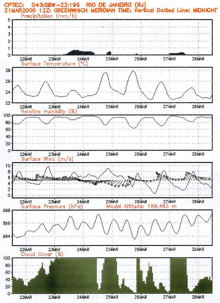 |
FIG. 3
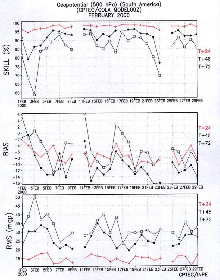 |
FIG. 4
 |
FIG. 5